La Viña geodata
La Viña (Salta) is a seat of a second-order administrative division; located in Argentina in America/Argentina/Salta (GMT-3) time zone. In our database, there are 785 cities with bigger population. Compared to other cities in Argentina, 93.7% of cities are located further ↓South; 78.5% of cities are located further →East and 94.8% of cities have lower elevation than La Viña. Note1


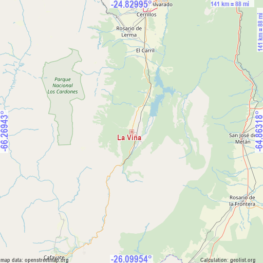
La Viña GPS coordinates[2]
25° 27' 59.112" South, 65° 33' 58.68" West
| Map corner | latitude | longitude |
|---|---|---|
| Upper-left | -24.82995°, | -66.26943° |
| Center: | -25.46642°, | -65.5663° |
| Lower-right: | -26.09954°, | -64.86318° |
| Map W x H: | 141.2×141.2 km | = 87.7×87.7mi |
| max Lat: | -21.94467° ⇑6.3% North |
| La Viña: | -25.46642° |
| min Lat: | ⇓93.7% South -54.81084° |
| min Long | La Viña | max Long |
| -72.88605° | -65.5663° | -53.64581° |
| W 21.5%⇐ | ⇒78.5% E |
Elevation
Elevation of La Viña is 1193 m = 3914 ft, and this is 843.7 m = 2768 ft above average elevation for this country.
| Max E: |
4040 m = 13255 ft | 5.2% |
| La Viña | 1193 m 3914 ft | |
| Avg. | 349.3 m = 1146 ft | |
Min E: |
-2 m = -7 ft | 94.8% |
See also: Argentina elevation on elevation.city.
Geographical zone
La Viña is located in South temperate zone (between Tropic of Capricorn and the Antarctic Circle). Distance of this Southern Tropic circle is 225.7 km =140.2 mi to North.| Distance of | km | miles | from La Viña |
|---|---|---|---|
| Equator | 2831.6 | 1759.5 | to North |
| Tropic Capricorn | 225.7 | 140.2 | to North |
| Antarctic Circle | 4569.6 | 2839.4 | to South |
| South Pole | 7175.5 | 4458.6 | to South |


Nearby cities:
15 places around La Viña: (largest is in red/bold)
• Cachí
71.5 km =44.4 mi,  302°
302°
• Cafayate
79 km =49.1 mi,  211°
211°
• Campo Quijano
62.3 km =38.7 mi,  353°
353°
• Cerrillos
63.7 km =39.6 mi,  7°
7°
• Chicoana
40.3 km =25 mi,  4°
4°
• El Carril
44.3 km =27.5 mi, 9°
• Guachipas
8.3 km =5.2 mi,  136°
136°
• La Candelaria
89.8 km =55.8 mi, 144°
• Metán
59.6 km =37 mi,  93°
93°
• Molinos
73.1 km =45.4 mi,  272°
272°
• Rosario de Lerma
53.9 km =33.5 mi,  358°
358°
• Rosario de la Frontera
70.1 km =43.6 mi,  121°
121°
• Salta
77.3 km =48 mi, 11°
• San Carlos
59.2 km =36.8 mi,  217°
217°
• Trancas
89.7 km =55.7 mi,  161°
161°
Sources, notices
• [Note1] Compared only with cities in Argentina existing in our database
• [Src1] Map data: © OpenStreetMap contributors (CC-BY-SA)
• [Src2] Other city data from geonames.org with taken over terms of usage.
• [Src3] Geographical zone / Annual Mean Temperature by Robert A. Rohde @ Wikipedia
