Cerrillos geodata
Cerrillos (Salta) is a seat of a second-order administrative division; located in Argentina in America/Argentina/Salta (GMT-3) time zone. In our database, there are 785 cities with bigger population. Compared to other cities in Argentina, 95.4% of cities are located further ↓South; 77.6% of cities are located further →East and 95.3% of cities have lower elevation than Cerrillos. Note1


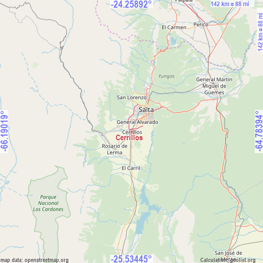
Cerrillos GPS coordinates[2]
24° 53' 53.988" South, 65° 29' 13.416" West
| Map corner | latitude | longitude |
|---|---|---|
| Upper-left | -24.25892°, | -66.19019° |
| Center: | -24.89833°, | -65.48706° |
| Lower-right: | -25.53445°, | -64.78394° |
| Map W x H: | 141.8×141.8 km | = 88.1×88.1mi |
| max Lat: | -21.94467° ⇑4.6% North |
| Cerrillos: | -24.89833° |
| min Lat: | ⇓95.4% South -54.81084° |
| min Long | Cerrillos | max Long |
| -72.88605° | -65.48706° | -53.64581° |
| W 22.4%⇐ | ⇒77.6% E |
Elevation
Elevation of Cerrillos is 1256 m = 4121 ft, and this is 906.7 m = 2975 ft above average elevation for this country.
| Max E: |
4040 m = 13255 ft | 4.7% |
| Cerrillos | 1256 m 4121 ft | |
| Avg. | 349.3 m = 1146 ft | |
Min E: |
-2 m = -7 ft | 95.3% |
See also: Argentina elevation on elevation.city.
Geographical zone
Cerrillos is located in South temperate zone (between Tropic of Capricorn and the Antarctic Circle). Distance of this Southern Tropic circle is 162.5 km =101 mi to North.| Distance of | km | miles | from Cerrillos |
|---|---|---|---|
| Equator | 2768.4 | 1720.2 | to North |
| Tropic Capricorn | 162.5 | 101 | to North |
| Antarctic Circle | 4632.7 | 2878.6 | to South |
| South Pole | 7238.6 | 4497.9 | to South |


Nearby cities:
15 places around Cerrillos: (largest is in red/bold)
• Cachí
72.7 km =45.2 mi,  250°
250°
• Campo Quijano
15.1 km =9.4 mi,  265°
265°
• Chicoana
23.5 km =14.6 mi,  191°
191°
• El Carmen
61.3 km =38.1 mi,  21°
21°
• El Carril
19.5 km =12.1 mi,  181°
181°
• General Martín Miguel de Güemes
51.1 km =31.8 mi,  60°
60°
• Guachipas
69.2 km =43 mi, 181°
• La Caldera
34.3 km =21.3 mi, 18°
• La Poma
74.7 km =46.4 mi,  285°
285°
• La Viña
63.7 km =39.6 mi, 187°
• Palpalá
76.6 km =47.6 mi, 21°
• Rosario de Lerma
13.1 km =8.1 mi,  224°
224°
• Salta
14.6 km =9.1 mi,  31°
31°
• San Antonio
61 km =37.9 mi,  14°
14°
• Santa Rosa de Tastil
69.9 km =43.4 mi,  315°
315°
Sources, notices
• [Note1] Compared only with cities in Argentina existing in our database
• [Src1] Map data: © OpenStreetMap contributors (CC-BY-SA)
• [Src2] Other city data from geonames.org with taken over terms of usage.
• [Src3] Geographical zone / Annual Mean Temperature by Robert A. Rohde @ Wikipedia
