General Ramírez geodata
General Ramírez (Entre Rios) is a populated place; located in Argentina in America/Argentina/Cordoba (GMT-3) time zone. With population of 8,614 people, there are 319 cities with bigger population in this country. Compared to other cities in Argentina, 53.4% of cities are located further ↑North; 66.6% of cities are located further ←West and 56.7% of cities have higher elevation than General Ramírez. Note1


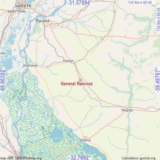
General Ramírez GPS coordinates[2]
32° 10' 33.636" South, 60° 12' 2.844" West
| Map corner | latitude | longitude |
|---|---|---|
| Upper-left | -31.57894°, | -60.90392° |
| Center: | -32.17601°, | -60.20079° |
| Lower-right: | -32.7692°, | -59.49767° |
| Map W x H: | 132.3×132.3 km | = 82.2×82.2mi |
| max Lat: | -21.94467° ⇑53.4% North |
| General Ramírez: | -32.17601° |
| min Lat: | ⇓46.6% South -54.81084° |
| min Long | General Ramíre | max Long |
| -72.88605° | -60.20079° | -53.64581° |
| W 66.6%⇐ | ⇒33.4% E |
Elevation
Elevation of General Ramírez is 117 m = 384 ft, and this is 232.3 m = 762 ft below average elevation for this country.
| Max E: |
4040 m = 13255 ft | 56.7% |
| Avg. | 349.3 m = 1146 ft | |
| General Ramírez | 117 m = 384 ft | |
Min E: |
-2 m = -7 ft | 43.3% |
See also: Argentina elevation on elevation.city.
Geographical zone
General Ramírez is located in South temperate zone (between Tropic of Capricorn and the Antarctic Circle). Distance of this Southern Tropic circle is 971.7 km =603.8 mi to North.| Distance of | km | miles | from General Ramírez |
|---|---|---|---|
| Equator | 3577.6 | 2223 | to North |
| Tropic Capricorn | 971.7 | 603.8 | to North |
| Antarctic Circle | 3823.5 | 2375.8 | to South |
| South Pole | 6429.4 | 3995 | to South |


Nearby cities:
15 places around General Ramírez: (largest is in red/bold)
• Aranguren
8.3 km =5.2 mi,  153°
153°
• Crespo
19.2 km =11.9 mi,  328°
328°
• Diamante
43 km =26.7 mi,  286°
286°
• Hernández
24.6 km =15.3 mi,  136°
136°
• Lucas González
67.2 km =41.8 mi,  110°
110°
• Nogoyá
45.6 km =28.3 mi,  122°
122°
• Oro Verde
49.1 km =30.5 mi,  322°
322°
• Paraná
58.2 km =36.2 mi, 327°
• San Benito
49.2 km =30.6 mi, 332°
• Seguí
25.4 km =15.8 mi,  16°
16°
• Tabossi
48.6 km =30.2 mi,  31°
31°
• Viale
38.8 km =24.1 mi, 28°
• Victoria
49.4 km =30.7 mi,  174°
174°
• Villa María Grande
63.4 km =39.4 mi, 26°
• Villa Urquiza
61 km =37.9 mi,  344°
344°
Sources, notices
• [Note1] Compared only with cities in Argentina existing in our database
• [Src1] Map data: © OpenStreetMap contributors (CC-BY-SA)
• [Src2] Other city data from geonames.org with taken over terms of usage.
• [Src3] Geographical zone / Annual Mean Temperature by Robert A. Rohde @ Wikipedia
