Lucas González geodata
Lucas González (Entre Rios) is a populated place; located in Argentina in America/Argentina/Cordoba (GMT-3) time zone. With population of 4,466 people, there are 470 cities with bigger population in this country. Compared to other cities in Argentina, 55.5% of cities are located further ↑North; 71.5% of cities are located further ←West and 64.7% of cities have higher elevation than Lucas González. Note1


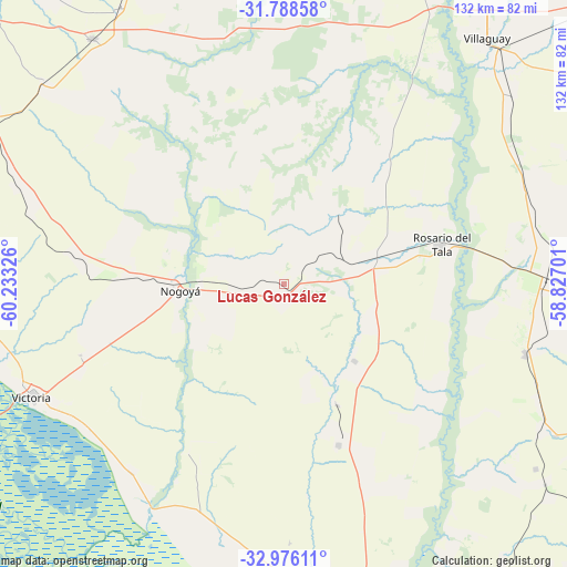
Lucas González GPS coordinates[2]
32° 23' 3.48" South, 59° 31' 48.468" West
| Map corner | latitude | longitude |
|---|---|---|
| Upper-left | -31.78858°, | -60.23326° |
| Center: | -32.3843°, | -59.53013° |
| Lower-right: | -32.97611°, | -58.82701° |
| Map W x H: | 132×132 km | = 82×82mi |
| max Lat: | -21.94467° ⇑55.5% North |
| Lucas González: | -32.3843° |
| min Lat: | ⇓44.5% South -54.81084° |
| min Long | Lucas González | max Long |
| -72.88605° | -59.53013° | -53.64581° |
| W 71.5%⇐ | ⇒28.5% E |
Elevation
Elevation of Lucas González is 94 m = 308 ft, and this is 255.3 m = 838 ft below average elevation for this country.
| Max E: |
4040 m = 13255 ft | 64.7% |
| Avg. | 349.3 m = 1146 ft | |
| Lucas González | 94 m = 308 ft | |
Min E: |
-2 m = -7 ft | 35.3% |
See also: Argentina elevation on elevation.city.
Geographical zone
Lucas González is located in South temperate zone (between Tropic of Capricorn and the Antarctic Circle). Distance of this Southern Tropic circle is 994.9 km =618.2 mi to North.| Distance of | km | miles | from Lucas González |
|---|---|---|---|
| Equator | 3600.8 | 2237.4 | to North |
| Tropic Capricorn | 994.9 | 618.2 | to North |
| Antarctic Circle | 3800.4 | 2361.5 | to South |
| South Pole | 6406.3 | 3980.7 | to South |


Nearby cities:
15 places around Lucas González: (largest is in red/bold)
• Aranguren
61.3 km =38.1 mi,  284°
284°
• Domínguez
69.3 km =43.1 mi,  50°
50°
• General Galarza
39.4 km =24.5 mi,  161°
161°
• General Ramírez
67.2 km =41.8 mi,  290°
290°
• Gilbert
58.6 km =36.4 mi,  106°
106°
• Gobernador Mansilla
24.2 km =15 mi,  137°
137°
• Hernández
46.5 km =28.9 mi, 276°
• Maciá
26.6 km =16.5 mi,  27°
27°
• Nogoyá
24.4 km =15.2 mi,  267°
267°
• Rosario del Tala
37.3 km =23.2 mi,  75°
75°
• Seguí
73.5 km =45.7 mi,  310°
310°
• Urdinarrain
68.5 km =42.6 mi,  119°
119°
• Viale
72.9 km =45.3 mi,  321°
321°
• Victoria
64.1 km =39.8 mi,  246°
246°
• Villa Mantero
73.6 km =45.7 mi,  91°
91°
Sources, notices
• [Note1] Compared only with cities in Argentina existing in our database
• [Src1] Map data: © OpenStreetMap contributors (CC-BY-SA)
• [Src2] Other city data from geonames.org with taken over terms of usage.
• [Src3] Geographical zone / Annual Mean Temperature by Robert A. Rohde @ Wikipedia
