Victoria geodata
Victoria (Entre Rios) is a populated place; located in Argentina in America/Argentina/Cordoba (GMT-3) time zone. With population of 25,139 people, there are 159 cities with bigger population in this country. Compared to other cities in Argentina, 57.7% of cities are located further ↑North; 66.9% of cities are located further ←West and 83.3% of cities have higher elevation than Victoria. Note1


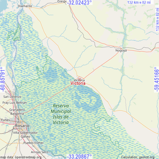
Victoria GPS coordinates[2]
32° 37' 6.276" South, 60° 9' 17.208" West
| Map corner | latitude | longitude |
|---|---|---|
| Upper-left | -32.02423°, | -60.85791° |
| Center: | -32.61841°, | -60.15478° |
| Lower-right: | -33.20867°, | -59.45166° |
| Map W x H: | 131.7×131.7 km | = 81.8×81.8mi |
| max Lat: | -21.94467° ⇑57.7% North |
| Victoria: | -32.61841° |
| min Lat: | ⇓42.3% South -54.81084° |
| min Long | Victoria | max Long |
| -72.88605° | -60.15478° | -53.64581° |
| W 66.9%⇐ | ⇒33.1% E |
Elevation
Elevation of Victoria is 52 m = 171 ft, and this is 297.3 m = 975 ft below average elevation for this country.
| Max E: |
4040 m = 13255 ft | 83.3% |
| Avg. | 349.3 m = 1146 ft | |
| Victoria | 52 m = 171 ft | |
Min E: |
-2 m = -7 ft | 16.7% |
See also: Argentina elevation on elevation.city.
Geographical zone
Victoria is located in South temperate zone (between Tropic of Capricorn and the Antarctic Circle). Distance of this Southern Tropic circle is 1020.9 km =634.4 mi to North.| Distance of | km | miles | from Victoria |
|---|---|---|---|
| Equator | 3626.8 | 2253.6 | to North |
| Tropic Capricorn | 1020.9 | 634.4 | to North |
| Antarctic Circle | 3774.3 | 2345.2 | to South |
| South Pole | 6380.2 | 3964.5 | to South |


Nearby cities:
15 places around Victoria: (largest is in red/bold)
• Aranguren
41.8 km =26 mi,  359°
359°
• Arroyo Seco
68.2 km =42.4 mi,  208°
208°
• Capitán Bermúdez
57.4 km =35.7 mi,  246°
246°
• Crespo
67.1 km =41.7 mi,  347°
347°
• Fray Luis A. Beltrán
57 km =35.4 mi, 250°
• Funes
69.6 km =43.2 mi,  241°
241°
• General Ramírez
49.4 km =30.7 mi, 354°
• Gobernador Gálvez
64.5 km =40.1 mi,  224°
224°
• Granadero Baigorria
58.9 km =36.6 mi, 243°
• Hernández
33.7 km =20.9 mi,  21°
21°
• Lucas González
64.1 km =39.8 mi,  66°
66°
• Nogoyá
42.4 km =26.3 mi,  53°
53°
• Rosario
58.2 km =36.2 mi,  231°
231°
• San Lorenzo
56.2 km =34.9 mi,  255°
255°
• Villa Constitución
69.7 km =43.3 mi,  193°
193°
Sources, notices
• [Note1] Compared only with cities in Argentina existing in our database
• [Src1] Map data: © OpenStreetMap contributors (CC-BY-SA)
• [Src2] Other city data from geonames.org with taken over terms of usage.
• [Src3] Geographical zone / Annual Mean Temperature by Robert A. Rohde @ Wikipedia
