Aranguren geodata
Aranguren (Entre Rios) is a populated place; located in Argentina in America/Argentina/Cordoba (GMT-3) time zone. With population of 1,581 people, there are 686 cities with bigger population in this country. Compared to other cities in Argentina, 54.2% of cities are located further ↑North; 66.8% of cities are located further ←West and 57.5% of cities have higher elevation than Aranguren. Note1


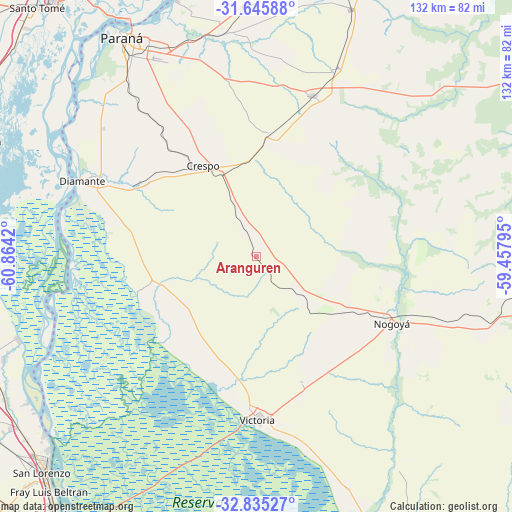
Aranguren GPS coordinates[2]
32° 14' 33.072" South, 60° 9' 39.852" West
| Map corner | latitude | longitude |
|---|---|---|
| Upper-left | -31.64588°, | -60.8642° |
| Center: | -32.24252°, | -60.16107° |
| Lower-right: | -32.83527°, | -59.45795° |
| Map W x H: | 132.2×132.2 km | = 82.1×82.1mi |
| max Lat: | -21.94467° ⇑54.2% North |
| Aranguren: | -32.24252° |
| min Lat: | ⇓45.8% South -54.81084° |
| min Long | Aranguren | max Long |
| -72.88605° | -60.16107° | -53.64581° |
| W 66.8%⇐ | ⇒33.2% E |
Elevation
Elevation of Aranguren is 114 m = 374 ft, and this is 235.3 m = 772 ft below average elevation for this country.
| Max E: |
4040 m = 13255 ft | 57.5% |
| Avg. | 349.3 m = 1146 ft | |
| Aranguren | 114 m = 374 ft | |
Min E: |
-2 m = -7 ft | 42.5% |
See also: Argentina elevation on elevation.city.
Geographical zone
Aranguren is located in South temperate zone (between Tropic of Capricorn and the Antarctic Circle). Distance of this Southern Tropic circle is 979.1 km =608.4 mi to North.| Distance of | km | miles | from Aranguren |
|---|---|---|---|
| Equator | 3585 | 2227.6 | to North |
| Tropic Capricorn | 979.1 | 608.4 | to North |
| Antarctic Circle | 3816.1 | 2371.2 | to South |
| South Pole | 6422 | 3990.4 | to South |


Nearby cities:
15 places around Aranguren: (largest is in red/bold)
• Crespo
27.4 km =17 mi,  330°
330°
• Diamante
49 km =30.4 mi,  293°
293°
• General Ramírez
8.3 km =5.2 mi, 333°
• Hernández
16.8 km =10.4 mi,  128°
128°
• Lucas González
61.3 km =38.1 mi,  104°
104°
• Nogoyá
38.8 km =24.1 mi,  115°
115°
• Oro Verde
57.3 km =35.6 mi,  324°
324°
• Paraná
66.5 km =41.3 mi, 328°
• San Benito
57.5 km =35.7 mi, 332°
• Seguí
32 km =19.9 mi,  6°
6°
• Tabossi
53.5 km =33.2 mi,  23°
23°
• Viale
44.1 km =27.4 mi, 19°
• Victoria
41.8 km =26 mi,  179°
179°
• Villa María Grande
68.6 km =42.6 mi, 20°
• Villa Urquiza
69.2 km =43 mi,  343°
343°
Sources, notices
• [Note1] Compared only with cities in Argentina existing in our database
• [Src1] Map data: © OpenStreetMap contributors (CC-BY-SA)
• [Src2] Other city data from geonames.org with taken over terms of usage.
• [Src3] Geographical zone / Annual Mean Temperature by Robert A. Rohde @ Wikipedia
