General Alvear geodata
General Alvear (Buenos Aires) is a seat of a second-order administrative division; located in Argentina in America/Argentina/Buenos_Aires (GMT-3) time zone. In our database, there are 785 cities with bigger population. Compared to other cities in Argentina, 81.6% of cities are located further ↑North; 67.9% of cities are located further ←West and 80.6% of cities have higher elevation than General Alvear. Note1


General Alvear GPS coordinates[2]
36° 1' 14.808" South, 60° 0' 52.2" West
| Map corner | latitude | longitude |
|---|---|---|
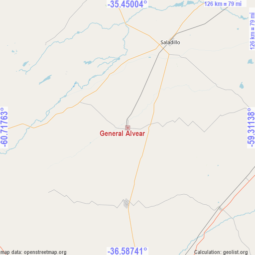
| Upper-left | -35.45004°, | -60.71763° |
| Center: | -36.02078°, | -60.0145° |
| Lower-right: | -36.58741°, | -59.31138° |
| Map W x H: | 126.5×126.5 km | = 78.6×78.6mi |
| max Lat: | -21.94467° ⇑81.6% North |
| General Alvear: | -36.02078° |
| min Lat: | ⇓18.4% South -54.81084° |
| min Long | General Alvear | max Long |
| -72.88605° | -60.0145° | -53.64581° |
| W 67.9%⇐ | ⇒32.1% E |
Elevation
Elevation of General Alvear is 57 m = 187 ft, and this is 292.3 m = 959 ft below average elevation for this country.
| Max E: |
4040 m = 13255 ft | 80.6% |
| Avg. | 349.3 m = 1146 ft | |
| General Alvear | 57 m = 187 ft | |
Min E: |
-2 m = -7 ft | 19.4% |
See also: Argentina elevation on elevation.city.
Geographical zone
General Alvear is located in South temperate zone (between Tropic of Capricorn and the Antarctic Circle). Distance of this Southern Tropic circle is 1399.2 km =869.4 mi to North.| Distance of | km | miles | from General Alvear |
|---|---|---|---|
| Equator | 4005.1 | 2488.7 | to North |
| Tropic Capricorn | 1399.2 | 869.4 | to North |
| Antarctic Circle | 3396 | 2110.2 | to South |
| South Pole | 6001.9 | 3729.4 | to South |


Nearby cities:
15 places around General Alvear: (largest is in red/bold)
• Alberti
113 km =70.2 mi,  347°
347°
• Azul
85.2 km =52.9 mi,  170°
170°
• Bragado
109.1 km =67.8 mi,  336°
336°
• Chivilcoy
125.1 km =77.7 mi,  359°
359°
• Las Flores
82.3 km =51.1 mi,  89°
89°
• Lobos
124.5 km =77.4 mi,  41°
41°
• Nueve de Julio
101.3 km =62.9 mi,  309°
309°
• Olavarría
100.8 km =62.6 mi,  195°
195°
• Rauch
117.8 km =73.2 mi,  135°
135°
• Roque Pérez
92.7 km =57.6 mi, 41°
• Saladillo
47.7 km =29.6 mi,  26°
26°
• San Carlos de Bolívar
101.6 km =63.1 mi,  256°
256°
• San Miguel del Monte
126.7 km =78.7 mi,  59°
59°
• Tapalqué
37.2 km =23.1 mi,  181°
181°
• Veinticinco de Mayo
67 km =41.6 mi, 347°
Sources, notices
• [Note1] Compared only with cities in Argentina existing in our database
• [Src1] Map data: © OpenStreetMap contributors (CC-BY-SA)
• [Src2] Other city data from geonames.org with taken over terms of usage.
• [Src3] Geographical zone / Annual Mean Temperature by Robert A. Rohde @ Wikipedia
