Tapalqué geodata
Tapalqué (Buenos Aires) is a seat of a second-order administrative division; located in Argentina in America/Argentina/Buenos_Aires (GMT-3) time zone. In our database, there are 785 cities with bigger population. Compared to other cities in Argentina, 82.9% of cities are located further ↑North; 67.6% of cities are located further ←West and 66.6% of cities have higher elevation than Tapalqué. Note1


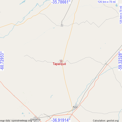
Tapalqué GPS coordinates[2]
36° 21' 17.748" South, 60° 1' 35.04" West
| Map corner | latitude | longitude |
|---|---|---|
| Upper-left | -35.78661°, | -60.72953° |
| Center: | -36.35493°, | -60.0264° |
| Lower-right: | -36.91914°, | -59.32328° |
| Map W x H: | 125.9×125.9 km | = 78.2×78.2mi |
| max Lat: | -21.94467° ⇑82.9% North |
| Tapalqué: | -36.35493° |
| min Lat: | ⇓17.1% South -54.81084° |
| min Long | Tapalqué | max Long |
| -72.88605° | -60.0264° | -53.64581° |
| W 67.6%⇐ | ⇒32.4% E |
Elevation
Elevation of Tapalqué is 90 m = 295 ft, and this is 259.3 m = 851 ft below average elevation for this country.
| Max E: |
4040 m = 13255 ft | 66.6% |
| Avg. | 349.3 m = 1146 ft | |
| Tapalqué | 90 m = 295 ft | |
Min E: |
-2 m = -7 ft | 33.4% |
See also: Argentina elevation on elevation.city.
Geographical zone
Tapalqué is located in South temperate zone (between Tropic of Capricorn and the Antarctic Circle). Distance of this Southern Tropic circle is 1436.4 km =892.5 mi to North.| Distance of | km | miles | from Tapalqué |
|---|---|---|---|
| Equator | 4042.3 | 2511.8 | to North |
| Tropic Capricorn | 1436.4 | 892.5 | to North |
| Antarctic Circle | 3358.9 | 2087.1 | to South |
| South Pole | 5964.8 | 3706.4 | to South |


Nearby cities:
15 places around Tapalqué: (largest is in red/bold)
• Azul
49.3 km =30.6 mi,  162°
162°
• Benito Juárez
147.7 km =91.8 mi,  172°
172°
• Bragado
143.6 km =89.2 mi,  343°
343°
• Carlos Casares
145.2 km =90.2 mi,  304°
304°
• General Alvear
37.2 km =23.1 mi,  1°
1°
• General La Madrid
148.2 km =92.1 mi,  227°
227°
• Las Flores
91.4 km =56.8 mi,  65°
65°
• Nueve de Julio
127.3 km =79.1 mi,  322°
322°
• Olavarría
65.4 km =40.6 mi,  203°
203°
• Rauch
95.8 km =59.5 mi,  119°
119°
• Roque Pérez
123.4 km =76.7 mi,  30°
30°
• Saladillo
82.9 km =51.5 mi,  15°
15°
• San Carlos de Bolívar
98.6 km =61.3 mi,  278°
278°
• Tandil
133.7 km =83.1 mi,  143°
143°
• Veinticinco de Mayo
103.4 km =64.2 mi,  352°
352°
Sources, notices
• [Note1] Compared only with cities in Argentina existing in our database
• [Src1] Map data: © OpenStreetMap contributors (CC-BY-SA)
• [Src2] Other city data from geonames.org with taken over terms of usage.
• [Src3] Geographical zone / Annual Mean Temperature by Robert A. Rohde @ Wikipedia
