Guaminí geodata
Guaminí (Buenos Aires) is a seat of a second-order administrative division; located in Argentina in America/Argentina/Buenos_Aires (GMT-3) time zone. In our database, there are 785 cities with bigger population. Compared to other cities in Argentina, 85.3% of cities are located further ↑North; 52.5% of cities are located further ←West and 59.2% of cities have higher elevation than Guaminí. Note1


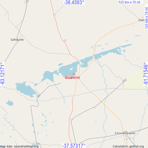
Guaminí GPS coordinates[2]
37° 0' 49.716" South, 62° 25' 6.888" West
| Map corner | latitude | longitude |
|---|---|---|
| Upper-left | -36.4503°, | -63.12171° |
| Center: | -37.01381°, | -62.41858° |
| Lower-right: | -37.57317°, | -61.71546° |
| Map W x H: | 124.9×124.9 km | = 77.6×77.6mi |
| max Lat: | -21.94467° ⇑85.3% North |
| Guaminí: | -37.01381° |
| min Lat: | ⇓14.7% South -54.81084° |
| min Long | Guaminí | max Long |
| -72.88605° | -62.41858° | -53.64581° |
| W 52.5%⇐ | ⇒47.5% E |
Elevation
Elevation of Guaminí is 110 m = 361 ft, and this is 239.3 m = 785 ft below average elevation for this country.
| Max E: |
4040 m = 13255 ft | 59.2% |
| Avg. | 349.3 m = 1146 ft | |
| Guaminí | 110 m = 361 ft | |
Min E: |
-2 m = -7 ft | 40.8% |
See also: Argentina elevation on elevation.city.
Geographical zone
Guaminí is located in South temperate zone (between Tropic of Capricorn and the Antarctic Circle). Distance of this Southern Tropic circle is 1509.6 km =938 mi to North.| Distance of | km | miles | from Guaminí |
|---|---|---|---|
| Equator | 4115.5 | 2557.3 | to North |
| Tropic Capricorn | 1509.6 | 938 | to North |
| Antarctic Circle | 3285.6 | 2041.6 | to South |
| South Pole | 5891.5 | 3660.8 | to South |


Nearby cities:
15 places around Guaminí: (largest is in red/bold)
• Carhué
35.1 km =21.8 mi,  238°
238°
• Catriló
112.1 km =69.7 mi,  307°
307°
• Coronel Suárez
65.2 km =40.5 mi,  138°
138°
• Daireaux
75.2 km =46.7 mi,  52°
52°
• General La Madrid
105.7 km =65.7 mi,  104°
104°
• General Manuel J. Campos
114.6 km =71.2 mi, 244°
• Henderson
101.1 km =62.8 mi,  38°
38°
• Macachín
111.5 km =69.3 mi,  263°
263°
• Miguel Riglos
114.2 km =71 mi,  278°
278°
• Pellegrini
106.6 km =66.2 mi,  321°
321°
• Pigüé
65.8 km =40.9 mi,  178°
178°
• Puan
66.7 km =41.4 mi,  207°
207°
• Salliqueló
56.3 km =35 mi,  301°
301°
• Trenque Lauquen
119.4 km =74.2 mi,  346°
346°
• Tres Lomas
73.4 km =45.6 mi,  327°
327°
Sources, notices
• [Note1] Compared only with cities in Argentina existing in our database
• [Src1] Map data: © OpenStreetMap contributors (CC-BY-SA)
• [Src2] Other city data from geonames.org with taken over terms of usage.
• [Src3] Geographical zone / Annual Mean Temperature by Robert A. Rohde @ Wikipedia
