Lerchenreith geodata
Lerchenreith (Styria) is a populated place; located in Austria in Europe/Vienna (GMT+2) time zone. With population of 822 people, there are 1575 cities with bigger population in this country. Compared to other cities in Austria, 50.8% of cities are located further ↓South; 70% of cities are located further →East and 80.3% of cities have lower elevation than Lerchenreith. Note1


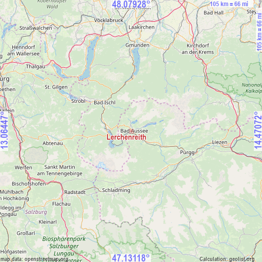
Lerchenreith GPS coordinates[2]
47° 36' 26.568" North, 13° 46' 3.324" East
| Map corner | latitude | longitude |
|---|---|---|
| Upper-left | 48.07928°, | 13.06447° |
| Center: | 47.60738°, | 13.76759° |
| Lower-right: | 47.13118°, | 14.47072° |
| Map W x H: | 105.4×105.4 km | = 65.5×65.5mi |
| max Lat: | 48.98333° ⇑49.2% North |
| Lerchenreith: | 47.60738° |
| min Lat: | ⇓50.8% South 46.48841° |
| min Long | Lerchenreith | max Long |
| 9.57802° | 13.76759° | 17.1° |
| W 30%⇐ | ⇒70% E |
Elevation
Elevation of Lerchenreith is 725 m = 2379 ft, and this is 219.5 m = 720 ft above average elevation for this country.
| Max E: |
2140 m = 7021 ft | 19.7% |
| Lerchenreith | 725 m 2379 ft | |
| Avg. | 505.5 m = 1658 ft | |
Min E: |
118 m = 387 ft | 80.3% |
See also: Austria elevation on elevation.city.
Geographical zone
Lerchenreith is located in North temperate zone (between Tropic of Cancer and the Arctic Circle). Distance of this North polar circle is 2107.7 km =1309.7 mi to North.| Distance of | km | miles | from Lerchenreith |
|---|---|---|---|
| North Pole | 4713.6 | 2928.9 | to North |
| Arctic Circle | 2107.7 | 1309.7 | to North |
| Tropic Cancer | 2687.5 | 1669.9 | to South |
| Equator | 5293.4 | 3289.2 | to South |


Nearby cities:
15 places around Lerchenreith: (largest is in red/bold)
• Altaussee
3.5 km =2.2 mi,  354°
354°
• Bad Aussee
1.1 km =0.7 mi,  75°
75°
• Bad Goisern
12 km =7.5 mi,  288°
288°
• Bad Ischl
16 km =9.9 mi,  316°
316°
• Gschwandt
11.6 km =7.2 mi,  283°
283°
• Mitterndorf im Steirischen Salzkammergut
13.6 km =8.5 mi,  115°
115°
• Neuhofen
14 km =8.7 mi, 117°
• Obertraun
8.2 km =5.1 mi,  227°
227°
• Obertressen
1.6 km =1 mi,  48°
48°
• Puchen
3 km =1.9 mi, 350°
• Reiterndorf
14.9 km =9.3 mi, 315°
• Rettenbach
15.9 km =9.9 mi,  329°
329°
• Steinfeld
15.5 km =9.6 mi, 319°
• Sulzbach
14.8 km =9.2 mi,  311°
311°
• Untersee
8.9 km =5.5 mi, 276°
Sources, notices
• [Note1] Compared only with cities in Austria existing in our database
• [Src1] Map data: © OpenStreetMap contributors (CC-BY-SA)
• [Src2] Other city data from geonames.org with taken over terms of usage.
• [Src3] Geographical zone / Annual Mean Temperature by Robert A. Rohde @ Wikipedia
