Obertressen geodata
Obertressen (Styria) is a populated place; located in Austria in Europe/Vienna (GMT+2) time zone. With population of 616 people, there are 2075 cities with bigger population in this country. Compared to other cities in Austria, 51.1% of cities are located further ↓South; 69.5% of cities are located further →East and 83.5% of cities have lower elevation than Obertressen. Note1


Obertressen GPS coordinates[2]
47° 37' 0.012" North, 13° 46' 59.988" East
| Map corner | latitude | longitude |
|---|---|---|
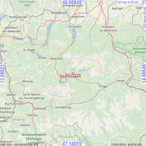
| Upper-left | 48.08849°, | 13.08021° |
| Center: | 47.61667°, | 13.78333° |
| Lower-right: | 47.14055°, | 14.48646° |
| Map W x H: | 105.4×105.4 km | = 65.5×65.5mi |
| max Lat: | 48.98333° ⇑48.9% North |
| Obertressen: | 47.61667° |
| min Lat: | ⇓51.1% South 46.48841° |
| min Long | Obertressen | max Long |
| 9.57802° | 13.78333° | 17.1° |
| W 30.5%⇐ | ⇒69.5% E |
Elevation
Elevation of Obertressen is 773 m = 2536 ft, and this is 267.5 m = 878 ft above average elevation for this country.
| Max E: |
2140 m = 7021 ft | 16.5% |
| Obertressen | 773 m 2536 ft | |
| Avg. | 505.5 m = 1658 ft | |
Min E: |
118 m = 387 ft | 83.5% |
See also: Austria elevation on elevation.city.
Geographical zone
Obertressen is located in North temperate zone (between Tropic of Cancer and the Arctic Circle). Distance of this North polar circle is 2106.7 km =1309 mi to North.| Distance of | km | miles | from Obertressen |
|---|---|---|---|
| North Pole | 4712.6 | 2928.3 | to North |
| Arctic Circle | 2106.7 | 1309 | to North |
| Tropic Cancer | 2688.6 | 1670.6 | to South |
| Equator | 5294.5 | 3289.8 | to South |


Nearby cities:
15 places around Obertressen: (largest is in red/bold)
• Altaussee
2.9 km =1.8 mi,  327°
327°
• Bad Aussee
0.7 km =0.4 mi,  185°
185°
• Bad Goisern
12.9 km =8 mi,  282°
282°
• Bad Ischl
16.2 km =10.1 mi,  310°
310°
• Gschwandt
12.5 km =7.8 mi, 277°
• Lerchenreith
1.6 km =1 mi,  228°
228°
• Mitterndorf im Steirischen Salzkammergut
13 km =8.1 mi,  121°
121°
• Neuhofen
13.5 km =8.4 mi, 123°
• Obertraun
9.8 km =6.1 mi, 227°
• Puchen
2.6 km =1.6 mi,  319°
319°
• Reiterndorf
15.1 km =9.4 mi, 309°
• Rettenbach
15.7 km =9.8 mi, 323°
• Steinfeld
15.5 km =9.6 mi, 313°
• Sulzbach
15.1 km =9.4 mi, 305°
• Untersee
10 km =6.2 mi,  270°
270°
Sources, notices
• [Note1] Compared only with cities in Austria existing in our database
• [Src1] Map data: © OpenStreetMap contributors (CC-BY-SA)
• [Src2] Other city data from geonames.org with taken over terms of usage.
• [Src3] Geographical zone / Annual Mean Temperature by Robert A. Rohde @ Wikipedia
