Zillingtal geodata
Zillingtal (Burgenland) is a seat of a third-order administrative division; located in Austria in Europe/Vienna (GMT+2) time zone. With population of 933 people, there are 1380 cities with bigger population in this country. Compared to other cities in Austria, 57.6% of cities are located further ↓South; 91.5% of cities are located further ←West and 89.8% of cities have higher elevation than Zillingtal. Note1


Zillingtal GPS coordinates[2]
47° 48' 51.912" North, 16° 24' 33.408" East
| Map corner | latitude | longitude |
|---|---|---|
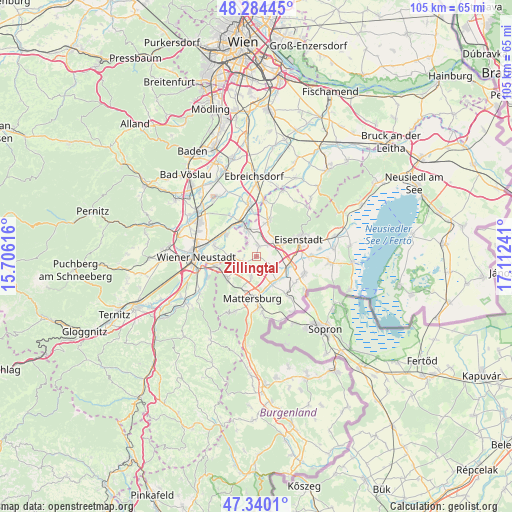
| Upper-left | 48.28445°, | 15.70616° |
| Center: | 47.81442°, | 16.40928° |
| Lower-right: | 47.3401°, | 17.11241° |
| Map W x H: | 105×105 km | = 65.2×65.2mi |
| max Lat: | 48.98333° ⇑42.4% North |
| Zillingtal: | 47.81442° |
| min Lat: | ⇓57.6% South 46.48841° |
| min Long | Zillingtal | max Long |
| 9.57802° | 16.40928° | 17.1° |
| W 91.5%⇐ | ⇒8.5% E |
Elevation
Elevation of Zillingtal is 214 m = 702 ft, and this is 291.5 m = 956 ft below average elevation for this country.
| Max E: |
2140 m = 7021 ft | 89.8% |
| Avg. | 505.5 m = 1658 ft | |
| Zillingtal | 214 m = 702 ft | |
Min E: |
118 m = 387 ft | 10.2% |
See also: Austria elevation on elevation.city.
Geographical zone
Zillingtal is located in North temperate zone (between Tropic of Cancer and the Arctic Circle). Distance of this North polar circle is 2084.7 km =1295.4 mi to North.| Distance of | km | miles | from Zillingtal |
|---|---|---|---|
| North Pole | 4690.6 | 2914.6 | to North |
| Arctic Circle | 2084.7 | 1295.4 | to North |
| Tropic Cancer | 2710.5 | 1684.2 | to South |
| Equator | 5316.5 | 3303.5 | to South |


Nearby cities:
15 places around Zillingtal: (largest is in red/bold)
• Antau
6.9 km =4.3 mi,  130°
130°
• Grosshöflein
5.8 km =3.6 mi,  65°
65°
• Hirm
4.6 km =2.9 mi, 132°
• Krensdorf
3.2 km =2 mi,  172°
172°
• Müllendorf
4.9 km =3 mi,  55°
55°
• Neufeld an der Leitha
6.1 km =3.8 mi,  338°
338°
• Pöttelsdorf
7.1 km =4.4 mi,  162°
162°
• Pöttsching
3.1 km =1.9 mi,  248°
248°
• Sigless
4.5 km =2.8 mi,  193°
193°
• Steinbrunn
2.2 km =1.4 mi,  14°
14°
• Stöttera
6.5 km =4 mi,  143°
143°
• Wulkaprodersdorf
7.4 km =4.6 mi,  104°
104°
• Zemendorf
6.5 km =4 mi,  151°
151°
• Zillingdorf
6.9 km =4.3 mi,  304°
304°
• Zillingdorf-Bergwerk
3.9 km =2.4 mi,  327°
327°
Sources, notices
• [Note1] Compared only with cities in Austria existing in our database
• [Src1] Map data: © OpenStreetMap contributors (CC-BY-SA)
• [Src2] Other city data from geonames.org with taken over terms of usage.
• [Src3] Geographical zone / Annual Mean Temperature by Robert A. Rohde @ Wikipedia
