Müllendorf geodata
Müllendorf (Burgenland) is a seat of a third-order administrative division; located in Austria in Europe/Vienna (GMT+2) time zone. With population of 1,397 people, there are 899 cities with bigger population in this country. Compared to other cities in Austria, 58.4% of cities are located further ↓South; 92.8% of cities are located further ←West and 87.4% of cities have higher elevation than Müllendorf. Note1


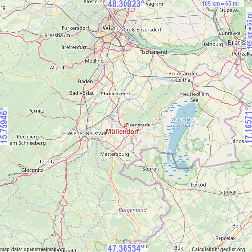
Müllendorf GPS coordinates[2]
47° 50' 21.948" North, 16° 27' 45.288" East
| Map corner | latitude | longitude |
|---|---|---|
| Upper-left | 48.30923°, | 15.75946° |
| Center: | 47.83943°, | 16.46258° |
| Lower-right: | 47.36534°, | 17.16571° |
| Map W x H: | 105×104.9 km | = 65.2×65.2mi |
| max Lat: | 48.98333° ⇑41.6% North |
| Müllendorf: | 47.83943° |
| min Lat: | ⇓58.4% South 46.48841° |
| min Long | Müllendorf | max Long |
| 9.57802° | 16.46258° | 17.1° |
| W 92.8%⇐ | ⇒7.2% E |
Elevation
Elevation of Müllendorf is 233 m = 764 ft, and this is 272.5 m = 894 ft below average elevation for this country.
| Max E: |
2140 m = 7021 ft | 87.4% |
| Avg. | 505.5 m = 1658 ft | |
| Müllendorf | 233 m = 764 ft | |
Min E: |
118 m = 387 ft | 12.6% |
See also: Austria elevation on elevation.city.
Geographical zone
Müllendorf is located in North temperate zone (between Tropic of Cancer and the Arctic Circle). Distance of this North polar circle is 2081.9 km =1293.6 mi to North.| Distance of | km | miles | from Müllendorf |
|---|---|---|---|
| North Pole | 4687.8 | 2912.9 | to North |
| Arctic Circle | 2081.9 | 1293.6 | to North |
| Tropic Cancer | 2713.3 | 1686 | to South |
| Equator | 5319.2 | 3305.2 | to South |


Nearby cities:
15 places around Müllendorf: (largest is in red/bold)
• Antau
7.4 km =4.6 mi,  169°
169°
• Eisenstadt
4.6 km =2.9 mi,  81°
81°
• Grosshöflein
1.4 km =0.9 mi,  106°
106°
• Hirm
5.9 km =3.7 mi,  185°
185°
• Hornstein
4.8 km =3 mi,  343°
343°
• Kleinhöflein im Burgenland
3.1 km =1.9 mi,  85°
85°
• Krensdorf
7 km =4.3 mi,  210°
210°
• Neufeld an der Leitha
6.9 km =4.3 mi,  294°
294°
• Pöttsching
7.9 km =4.9 mi,  240°
240°
• Sankt Georgen am Leithagebirge
6.6 km =4.1 mi, 79°
• Steinbrunn
3.5 km =2.2 mi,  258°
258°
• Trausdorf an der Wulka
7.7 km =4.8 mi, 112°
• Wulkaprodersdorf
5.6 km =3.5 mi,  146°
146°
• Zillingdorf-Bergwerk
6.1 km =3.8 mi,  274°
274°
• Zillingtal
4.9 km =3 mi, 235°
Sources, notices
• [Note1] Compared only with cities in Austria existing in our database
• [Src1] Map data: © OpenStreetMap contributors (CC-BY-SA)
• [Src2] Other city data from geonames.org with taken over terms of usage.
• [Src3] Geographical zone / Annual Mean Temperature by Robert A. Rohde @ Wikipedia
