Wolfsgraben geodata
Wolfsgraben (Lower Austria) is a seat of a third-order administrative division; located in Austria in Europe/Vienna (GMT+2) time zone. With population of 1,700 people, there are 737 cities with bigger population in this country. Compared to other cities in Austria, 76.2% of cities are located further ↓South; 83.9% of cities are located further ←West and 70.9% of cities have higher elevation than Wolfsgraben. Note1
Administrative division(s):
- Level 1: Lower Austria
- Level 2: Politischer Bezirk Sankt Pölten
- Level 3: Wolfsgraben


Wolfsgraben GPS coordinates[2]
48° 9' 31.32" North, 16° 7' 15.528" East
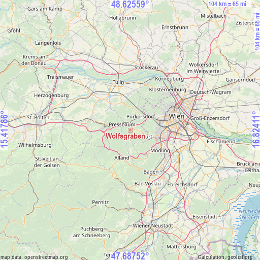
| Map corner | latitude | longitude |
|---|---|---|
| Upper-left | 48.62559°, | 15.41786° |
| Center: | 48.1587°, | 16.12098° |
| Lower-right: | 47.68752°, | 16.82411° |
| Map W x H: | 104.3×104.3 km | = 64.8×64.8mi |
| max Lat: | 48.98333° ⇑23.8% North |
| Wolfsgraben: | 48.1587° |
| min Lat: | ⇓76.2% South 46.48841° |
| min Long | Wolfsgraben | max Long |
| 9.57802° | 16.12098° | 17.1° |
| W 83.9%⇐ | ⇒16.1% E |
Elevation
Elevation of Wolfsgraben is 323 m = 1060 ft, and this is 182.5 m = 599 ft below average elevation for this country.
| Max E: |
2140 m = 7021 ft | 70.9% |
| Avg. | 505.5 m = 1658 ft | |
| Wolfsgraben | 323 m = 1060 ft | |
Min E: |
118 m = 387 ft | 29.1% |
See also: Austria elevation on elevation.city.
Geographical zone
Wolfsgraben is located in North temperate zone (between Tropic of Cancer and the Arctic Circle). Distance of this North polar circle is 2046.4 km =1271.6 mi to North.| Distance of | km | miles | from Wolfsgraben |
|---|---|---|---|
| North Pole | 4652.3 | 2890.8 | to North |
| Arctic Circle | 2046.4 | 1271.6 | to North |
| Tropic Cancer | 2748.8 | 1708 | to South |
| Equator | 5354.7 | 3327.3 | to South |


Nearby cities:
15 places around Wolfsgraben: (largest is in red/bold)
• Breitenfurt bei Wien
3.5 km =2.2 mi,  142°
142°
• Eichgraben
10.3 km =6.4 mi,  278°
278°
• Gablitz
8.2 km =5.1 mi,  17°
17°
• Grub
8.9 km =5.5 mi,  184°
184°
• Irenental
5.4 km =3.4 mi,  342°
342°
• Kaltenleutgeben
7.5 km =4.7 mi,  128°
128°
• Laab im Walde
3.9 km =2.4 mi,  96°
96°
• Mauerbach
10.2 km =6.3 mi, 19°
• Pfalzau
4.3 km =2.7 mi,  272°
272°
• Pressbaum
3.9 km =2.4 mi,  314°
314°
• Purkersdorf
6.8 km =4.2 mi,  36°
36°
• Rekawinkel
7.5 km =4.7 mi,  287°
287°
• Sittendorf
9.7 km =6 mi,  161°
161°
• Sulz im Wienerwald
6.6 km =4.1 mi,  169°
169°
• Tullnerbach-Lawies
4 km =2.5 mi,  326°
326°
Sources, notices
• [Note1] Compared only with cities in Austria existing in our database
• [Src1] Map data: © OpenStreetMap contributors (CC-BY-SA)
• [Src2] Other city data from geonames.org with taken over terms of usage.
• [Src3] Geographical zone / Annual Mean Temperature by Robert A. Rohde @ Wikipedia
