Tulfes geodata
Tulfes (Tyrol) is a seat of a third-order administrative division; located in Austria in Europe/Vienna (GMT+2) time zone. With population of 1,089 people, there are 1175 cities with bigger population in this country. Compared to other cities in Austria, 68.6% of cities are located further ↑North; 91.2% of cities are located further →East and 91.6% of cities have lower elevation than Tulfes. Note1
Administrative division(s):
- Level 1: Tyrol
- Level 2: Politischer Bezirk Innsbruck Land
- Level 3: Tulfes


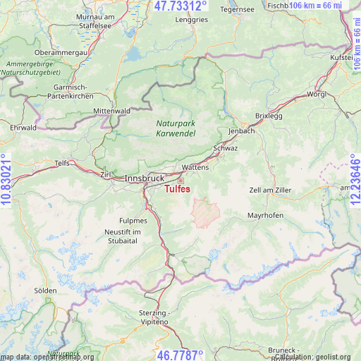
Tulfes GPS coordinates[2]
47° 15' 29.016" North, 11° 31' 59.988" East
| Map corner | latitude | longitude |
|---|---|---|
| Upper-left | 47.73312°, | 10.83021° |
| Center: | 47.25806°, | 11.53333° |
| Lower-right: | 46.7787°, | 12.23646° |
| Map W x H: | 106.1×106.1 km | = 65.9×65.9mi |
| max Lat: | 48.98333° ⇑68.6% North |
| Tulfes: | 47.25806° |
| min Lat: | ⇓31.4% South 46.48841° |
| min Long | Tulfes | max Long |
| 9.57802° | 11.53333° | 17.1° |
| W 8.8%⇐ | ⇒91.2% E |
Elevation
Elevation of Tulfes is 912 m = 2992 ft, and this is 406.5 m = 1334 ft above average elevation for this country.
| Max E: |
2140 m = 7021 ft | 8.4% |
| Tulfes | 912 m 2992 ft | |
| Avg. | 505.5 m = 1658 ft | |
Min E: |
118 m = 387 ft | 91.6% |
See also: Austria elevation on elevation.city.
Geographical zone
Tulfes is located in North temperate zone (between Tropic of Cancer and the Arctic Circle). Distance of this North polar circle is 2146.6 km =1333.8 mi to North.| Distance of | km | miles | from Tulfes |
|---|---|---|---|
| North Pole | 4752.5 | 2953.1 | to North |
| Arctic Circle | 2146.6 | 1333.8 | to North |
| Tropic Cancer | 2648.7 | 1645.8 | to South |
| Equator | 5254.6 | 3265.1 | to South |


Nearby cities:
15 places around Tulfes: (largest is in red/bold)
• Absam
4.7 km =2.9 mi,  333°
333°
• Aldrans
6.4 km =4 mi,  261°
261°
• Ampass
5.4 km =3.4 mi,  275°
275°
• Baumkirchen
5.3 km =3.3 mi,  28°
28°
• Fritzens
6.8 km =4.2 mi,  38°
38°
• Hall in Tirol
3.1 km =1.9 mi,  335°
335°
• Heiligkreuz
4.3 km =2.7 mi,  315°
315°
• Mils bei Solbad Hall
2.8 km =1.7 mi,  0°
0°
• Rinn
2.7 km =1.7 mi,  250°
250°
• Rum
6.9 km =4.3 mi,  294°
294°
• Sistrans
6.9 km =4.3 mi, 246°
• Thaur
6 km =3.7 mi,  312°
312°
• Volders
3.8 km =2.4 mi, 41°
• Wattenberg
5.8 km =3.6 mi,  60°
60°
• Wattens
5.9 km =3.7 mi,  47°
47°
Sources, notices
• [Note1] Compared only with cities in Austria existing in our database
• [Src1] Map data: © OpenStreetMap contributors (CC-BY-SA)
• [Src2] Other city data from geonames.org with taken over terms of usage.
• [Src3] Geographical zone / Annual Mean Temperature by Robert A. Rohde @ Wikipedia
