Hall in Tirol geodata
Hall in Tirol (Tyrol) is a seat of a third-order administrative division; located in Austria in Europe/Vienna (GMT+2) time zone. With population of 13,334 people, there are 54 cities with bigger population in this country. Compared to other cities in Austria, 67.2% of cities are located further ↑North; 91.3% of cities are located further →East and 69.8% of cities have lower elevation than Hall in Tirol. Note1
Administrative division(s):
- Level 1: Tyrol
- Level 2: Politischer Bezirk Innsbruck Land
- Level 3: Hall in Tirol


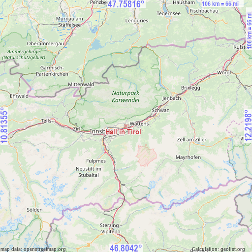
Hall in Tirol GPS coordinates[2]
47° 16' 59.988" North, 11° 31' 0.012" East
| Map corner | latitude | longitude |
|---|---|---|
| Upper-left | 47.75816°, | 10.81355° |
| Center: | 47.28333°, | 11.51667° |
| Lower-right: | 46.8042°, | 12.2198° |
| Map W x H: | 106.1×106.1 km | = 65.9×65.9mi |
| max Lat: | 48.98333° ⇑67.2% North |
| Hall in Tirol: | 47.28333° |
| min Lat: | ⇓32.8% South 46.48841° |
| min Long | Hall in Tirol | max Long |
| 9.57802° | 11.51667° | 17.1° |
| W 8.7%⇐ | ⇒91.3% E |
Elevation
Elevation of Hall in Tirol is 587 m = 1926 ft, and this is 81.5 m = 267 ft above average elevation for this country.
| Max E: |
2140 m = 7021 ft | 30.2% |
| Hall in Tirol | 587 m 1926 ft | |
| Avg. | 505.5 m = 1658 ft | |
Min E: |
118 m = 387 ft | 69.8% |
See also: Austria elevation on elevation.city.
Geographical zone
Hall in Tirol is located in North temperate zone (between Tropic of Cancer and the Arctic Circle). Distance of this North polar circle is 2143.8 km =1332.1 mi to North.| Distance of | km | miles | from Hall in Tirol |
|---|---|---|---|
| North Pole | 4749.6 | 2951.3 | to North |
| Arctic Circle | 2143.8 | 1332.1 | to North |
| Tropic Cancer | 2651.5 | 1647.6 | to South |
| Equator | 5257.4 | 3266.8 | to South |


Nearby cities:
15 places around Hall in Tirol: (largest is in red/bold)
• Absam
1.6 km =1 mi,  329°
329°
• Aldrans
6.2 km =3.9 mi,  233°
233°
• Ampass
4.7 km =2.9 mi,  240°
240°
• Baumkirchen
4.2 km =2.6 mi,  63°
63°
• Fritzens
6 km =3.7 mi,  65°
65°
• Gnadenwald
5.3 km =3.3 mi,  45°
45°
• Heiligkreuz
1.8 km =1.1 mi,  279°
279°
• Mils bei Solbad Hall
1.3 km =0.8 mi,  90°
90°
• Rinn
3.9 km =2.4 mi,  198°
198°
• Rum
5 km =3.1 mi,  270°
270°
• Thaur
3.4 km =2.1 mi,  292°
292°
• Tulfes
3.1 km =1.9 mi,  155°
155°
• Volders
3.8 km =2.4 mi, 90°
• Wattenberg
6.3 km =3.9 mi, 90°
• Wattens
5.7 km =3.5 mi,  77°
77°
Sources, notices
• [Note1] Compared only with cities in Austria existing in our database
• [Src1] Map data: © OpenStreetMap contributors (CC-BY-SA)
• [Src2] Other city data from geonames.org with taken over terms of usage.
• [Src3] Geographical zone / Annual Mean Temperature by Robert A. Rohde @ Wikipedia
