Habach geodata
Habach (Salzburg) is a populated place; located in Austria in Europe/Vienna (GMT+2) time zone. With population of 1,092 people, there are 1172 cities with bigger population in this country. Compared to other cities in Austria, 57.7% of cities are located further ↓South; 79.9% of cities are located further →East and 78.7% of cities have lower elevation than Habach. Note1
Administrative division(s):
- Level 1: Salzburg
- Level 2: Politischer Bezirk Salzburg-Umgebung
- Level 3: Koppl


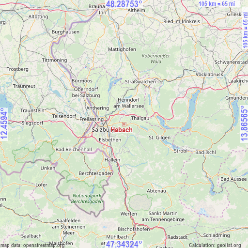
Habach GPS coordinates[2]
47° 49' 3.108" North, 13° 9' 45.072" East
| Map corner | latitude | longitude |
|---|---|---|
| Upper-left | 48.28753°, | 12.4594° |
| Center: | 47.81753°, | 13.16252° |
| Lower-right: | 47.34324°, | 13.86565° |
| Map W x H: | 105×105 km | = 65.2×65.2mi |
| max Lat: | 48.98333° ⇑42.3% North |
| Habach: | 47.81753° |
| min Lat: | ⇓57.7% South 46.48841° |
| min Long | Habach | max Long |
| 9.57802° | 13.16252° | 17.1° |
| W 20.1%⇐ | ⇒79.9% E |
Elevation
Elevation of Habach is 696 m = 2283 ft, and this is 190.5 m = 625 ft above average elevation for this country.
| Max E: |
2140 m = 7021 ft | 21.3% |
| Habach | 696 m 2283 ft | |
| Avg. | 505.5 m = 1658 ft | |
Min E: |
118 m = 387 ft | 78.7% |
See also: Austria elevation on elevation.city.
Geographical zone
Habach is located in North temperate zone (between Tropic of Cancer and the Arctic Circle). Distance of this North polar circle is 2084.4 km =1295.2 mi to North.| Distance of | km | miles | from Habach |
|---|---|---|---|
| North Pole | 4690.3 | 2914.4 | to North |
| Arctic Circle | 2084.4 | 1295.2 | to North |
| Tropic Cancer | 2710.9 | 1684.5 | to South |
| Equator | 5316.8 | 3303.7 | to South |


Nearby cities:
15 places around Habach: (largest is in red/bold)
• Ebenau
3.1 km =1.9 mi,  162°
162°
• Enzersberg
4.6 km =2.9 mi,  37°
37°
• Esch
5.8 km =3.6 mi,  295°
295°
• Eugenbach
6 km =3.7 mi,  338°
338°
• Eugendorf
6.2 km =3.9 mi,  333°
333°
• Faistenau
6.9 km =4.3 mi,  129°
129°
• Hallwang
6.9 km =4.3 mi, 301°
• Hof bei Salzburg
3.9 km =2.4 mi,  87°
87°
• Koppl
1.2 km =0.7 mi,  206°
206°
• Plainfeld
2.3 km =1.4 mi, 41°
• Reitberg
3.9 km =2.4 mi,  354°
354°
• Schwaighofen
2.4 km =1.5 mi,  309°
309°
• Unterdorf
5.7 km =3.5 mi,  58°
58°
• Vorderschroffenau
2.8 km =1.7 mi,  137°
137°
• Zilling
5.9 km =3.7 mi, 307°
Sources, notices
• [Note1] Compared only with cities in Austria existing in our database
• [Src1] Map data: © OpenStreetMap contributors (CC-BY-SA)
• [Src2] Other city data from geonames.org with taken over terms of usage.
• [Src3] Geographical zone / Annual Mean Temperature by Robert A. Rohde @ Wikipedia
