Koppl geodata
Koppl (Salzburg) is a seat of a third-order administrative division; located in Austria in Europe/Vienna (GMT+2) time zone. With population of 453 people, there are 2561 cities with bigger population in this country. Compared to other cities in Austria, 57.5% of cities are located further ↓South; 80% of cities are located further →East and 81.8% of cities have lower elevation than Koppl. Note1
Administrative division(s):
- Level 1: Salzburg
- Level 2: Politischer Bezirk Salzburg-Umgebung
- Level 3: Koppl


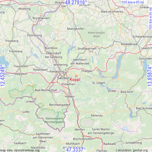
Koppl GPS coordinates[2]
47° 48' 29.088" North, 13° 9' 20.196" East
| Map corner | latitude | longitude |
|---|---|---|
| Upper-left | 48.27816°, | 12.45249° |
| Center: | 47.80808°, | 13.15561° |
| Lower-right: | 47.3337°, | 13.85874° |
| Map W x H: | 105×105 km | = 65.2×65.2mi |
| max Lat: | 48.98333° ⇑42.5% North |
| Koppl: | 47.80808° |
| min Lat: | ⇓57.5% South 46.48841° |
| min Long | Koppl | max Long |
| 9.57802° | 13.15561° | 17.1° |
| W 20%⇐ | ⇒80% E |
Elevation
Elevation of Koppl is 748 m = 2454 ft, and this is 242.5 m = 796 ft above average elevation for this country.
| Max E: |
2140 m = 7021 ft | 18.2% |
| Koppl | 748 m 2454 ft | |
| Avg. | 505.5 m = 1658 ft | |
Min E: |
118 m = 387 ft | 81.8% |
See also: Austria elevation on elevation.city.
Geographical zone
Koppl is located in North temperate zone (between Tropic of Cancer and the Arctic Circle). Distance of this North polar circle is 2085.4 km =1295.8 mi to North.| Distance of | km | miles | from Koppl |
|---|---|---|---|
| North Pole | 4691.3 | 2915 | to North |
| Arctic Circle | 2085.4 | 1295.8 | to North |
| Tropic Cancer | 2709.8 | 1683.8 | to South |
| Equator | 5315.8 | 3303.1 | to South |


Nearby cities:
15 places around Koppl: (largest is in red/bold)
• Ebenau
2.4 km =1.5 mi,  142°
142°
• Enzersberg
5.7 km =3.5 mi,  35°
35°
• Esch
5.9 km =3.7 mi,  307°
307°
• Eugenbach
6.9 km =4.3 mi,  345°
345°
• Eugendorf
7 km =4.3 mi,  341°
341°
• Faistenau
6.8 km =4.2 mi,  120°
120°
• Glasenbach
7.1 km =4.4 mi,  229°
229°
• Habach
1.2 km =0.7 mi,  26°
26°
• Hof bei Salzburg
4.6 km =2.9 mi,  74°
74°
• Plainfeld
3.5 km =2.2 mi, 36°
• Reitberg
5 km =3.1 mi,  1°
1°
• Schwaighofen
2.9 km =1.8 mi,  331°
331°
• Unterdorf
6.7 km =4.2 mi,  52°
52°
• Vorderschroffenau
2.6 km =1.6 mi,  112°
112°
• Zilling
6.2 km =3.9 mi,  318°
318°
Sources, notices
• [Note1] Compared only with cities in Austria existing in our database
• [Src1] Map data: © OpenStreetMap contributors (CC-BY-SA)
• [Src2] Other city data from geonames.org with taken over terms of usage.
• [Src3] Geographical zone / Annual Mean Temperature by Robert A. Rohde @ Wikipedia
