Ebenau geodata
Ebenau (Salzburg) is a seat of a third-order administrative division; located in Austria in Europe/Vienna (GMT+2) time zone. With population of 198 people, there are 2853 cities with bigger population in this country. Compared to other cities in Austria, 56.8% of cities are located further ↓South; 79.8% of cities are located further →East and 71.3% of cities have lower elevation than Ebenau. Note1
Administrative division(s):
- Level 1: Salzburg
- Level 2: Politischer Bezirk Salzburg-Umgebung
- Level 3: Ebenau


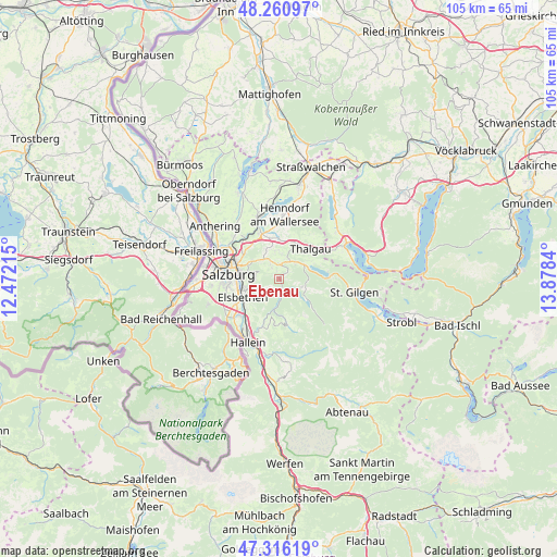
Ebenau GPS coordinates[2]
47° 47' 26.628" North, 13° 10' 30.972" East
| Map corner | latitude | longitude |
|---|---|---|
| Upper-left | 48.26097°, | 12.47215° |
| Center: | 47.79073°, | 13.17527° |
| Lower-right: | 47.31619°, | 13.8784° |
| Map W x H: | 105×105 km | = 65.2×65.2mi |
| max Lat: | 48.98333° ⇑43.2% North |
| Ebenau: | 47.79073° |
| min Lat: | ⇓56.8% South 46.48841° |
| min Long | Ebenau | max Long |
| 9.57802° | 13.17527° | 17.1° |
| W 20.2%⇐ | ⇒79.8% E |
Elevation
Elevation of Ebenau is 604 m = 1982 ft, and this is 98.5 m = 323 ft above average elevation for this country.
| Max E: |
2140 m = 7021 ft | 28.7% |
| Ebenau | 604 m 1982 ft | |
| Avg. | 505.5 m = 1658 ft | |
Min E: |
118 m = 387 ft | 71.3% |
See also: Austria elevation on elevation.city.
Geographical zone
Ebenau is located in North temperate zone (between Tropic of Cancer and the Arctic Circle). Distance of this North polar circle is 2087.3 km =1297 mi to North.| Distance of | km | miles | from Ebenau |
|---|---|---|---|
| North Pole | 4693.2 | 2916.2 | to North |
| Arctic Circle | 2087.3 | 1297 | to North |
| Tropic Cancer | 2707.9 | 1682.6 | to South |
| Equator | 5313.8 | 3301.8 | to South |


Nearby cities:
15 places around Ebenau: (largest is in red/bold)
• Anger
5.1 km =3.2 mi,  121°
121°
• Elsbethen
7.6 km =4.7 mi,  247°
247°
• Enzersberg
6.8 km =4.2 mi,  15°
15°
• Faistenau
4.6 km =2.9 mi,  108°
108°
• Glasenbach
7.4 km =4.6 mi, 248°
• Habach
3.1 km =1.9 mi,  342°
342°
• Hof bei Salzburg
4.3 km =2.7 mi,  42°
42°
• Koppl
2.4 km =1.5 mi,  322°
322°
• Plainfeld
4.8 km =3 mi,  7°
7°
• Reitberg
7 km =4.3 mi,  348°
348°
• Schwaighofen
5.3 km =3.3 mi,  327°
327°
• Thalgau
8.1 km =5 mi,  45°
45°
• Unterdorf
7.2 km =4.5 mi,  33°
33°
• Vorderschroffenau
1.3 km =0.8 mi, 43°
• Vordersee
7.2 km =4.5 mi,  129°
129°
Sources, notices
• [Note1] Compared only with cities in Austria existing in our database
• [Src1] Map data: © OpenStreetMap contributors (CC-BY-SA)
• [Src2] Other city data from geonames.org with taken over terms of usage.
• [Src3] Geographical zone / Annual Mean Temperature by Robert A. Rohde @ Wikipedia
