Tiefgraben geodata
Tiefgraben (Upper Austria) is a seat of a third-order administrative division; located in Austria in Europe/Vienna (GMT+2) time zone. With population of 1,585 people, there are 791 cities with bigger population in this country. Compared to other cities in Austria, 59.9% of cities are located further ↓South; 77.7% of cities are located further →East and 67.1% of cities have lower elevation than Tiefgraben. Note1
Administrative division(s):
- Level 1: Upper Austria
- Level 2: Politischer Bezirk Vöcklabruck
- Level 3: Tiefgraben


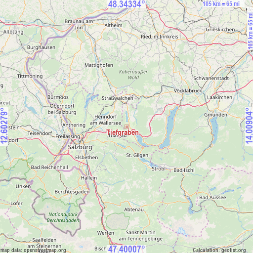
Tiefgraben GPS coordinates[2]
47° 52' 25.86" North, 13° 18' 21.276" East
| Map corner | latitude | longitude |
|---|---|---|
| Upper-left | 48.34334°, | 12.60279° |
| Center: | 47.87385°, | 13.30591° |
| Lower-right: | 47.40007°, | 14.00904° |
| Map W x H: | 104.9×104.9 km | = 65.2×65.2mi |
| max Lat: | 48.98333° ⇑40.1% North |
| Tiefgraben: | 47.87385° |
| min Lat: | ⇓59.9% South 46.48841° |
| min Long | Tiefgraben | max Long |
| 9.57802° | 13.30591° | 17.1° |
| W 22.3%⇐ | ⇒77.7% E |
Elevation
Elevation of Tiefgraben is 566 m = 1857 ft, and this is 60.5 m = 198 ft above average elevation for this country.
| Max E: |
2140 m = 7021 ft | 32.9% |
| Tiefgraben | 566 m 1857 ft | |
| Avg. | 505.5 m = 1658 ft | |
Min E: |
118 m = 387 ft | 67.1% |
See also: Austria elevation on elevation.city.
Geographical zone
Tiefgraben is located in North temperate zone (between Tropic of Cancer and the Arctic Circle). Distance of this North polar circle is 2078.1 km =1291.3 mi to North.| Distance of | km | miles | from Tiefgraben |
|---|---|---|---|
| North Pole | 4684 | 2910.5 | to North |
| Arctic Circle | 2078.1 | 1291.3 | to North |
| Tropic Cancer | 2717.2 | 1688.4 | to South |
| Equator | 5323.1 | 3307.6 | to South |


Nearby cities:
15 places around Tiefgraben: (largest is in red/bold)
• Enzersberg
8.3 km =5.2 mi,  251°
251°
• Fuschl am See
8.2 km =5.1 mi,  183°
183°
• Gaisberg
3.4 km =2.1 mi,  137°
137°
• Guggenberg
2.3 km =1.4 mi,  62°
62°
• Hof
1.1 km =0.7 mi,  134°
134°
• Hof bei Salzburg
9.1 km =5.7 mi,  228°
228°
• Innerschwand
8.3 km =5.2 mi,  122°
122°
• Keuschen
4.5 km =2.8 mi,  185°
185°
• Mondsee
3.8 km =2.4 mi, 120°
• Oberhofen am Irrsee
8.5 km =5.3 mi,  357°
357°
• Sankt Lorenz
5.6 km =3.5 mi,  145°
145°
• Thalgau
5.3 km =3.3 mi, 227°
• Thalgauberg
3.8 km =2.4 mi,  242°
242°
• Unterdorf
6.7 km =4.2 mi, 240°
• Zell am Moos
3 km =1.9 mi,  15°
15°
Sources, notices
• [Note1] Compared only with cities in Austria existing in our database
• [Src1] Map data: © OpenStreetMap contributors (CC-BY-SA)
• [Src2] Other city data from geonames.org with taken over terms of usage.
• [Src3] Geographical zone / Annual Mean Temperature by Robert A. Rohde @ Wikipedia
