Thalgau geodata
Thalgau (Salzburg) is a seat of a third-order administrative division; located in Austria in Europe/Vienna (GMT+2) time zone. With population of 2,424 people, there are 494 cities with bigger population in this country. Compared to other cities in Austria, 58.5% of cities are located further ↓South; 78.2% of cities are located further →East and 64.2% of cities have lower elevation than Thalgau. Note1
Administrative division(s):
- Level 1: Salzburg
- Level 2: Politischer Bezirk Salzburg-Umgebung
- Level 3: Thalgau


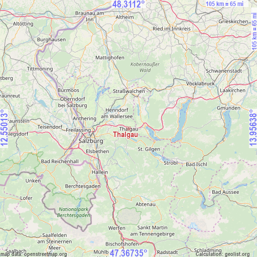
Thalgau GPS coordinates[2]
47° 50' 29.112" North, 13° 15' 11.7" East
| Map corner | latitude | longitude |
|---|---|---|
| Upper-left | 48.3112°, | 12.55013° |
| Center: | 47.84142°, | 13.25325° |
| Lower-right: | 47.36735°, | 13.95638° |
| Map W x H: | 104.9×104.9 km | = 65.2×65.2mi |
| max Lat: | 48.98333° ⇑41.5% North |
| Thalgau: | 47.84142° |
| min Lat: | ⇓58.5% South 46.48841° |
| min Long | Thalgau | max Long |
| 9.57802° | 13.25325° | 17.1° |
| W 21.8%⇐ | ⇒78.2% E |
Elevation
Elevation of Thalgau is 546 m = 1791 ft, and this is 40.5 m = 133 ft above average elevation for this country.
| Max E: |
2140 m = 7021 ft | 35.8% |
| Thalgau | 546 m 1791 ft | |
| Avg. | 505.5 m = 1658 ft | |
Min E: |
118 m = 387 ft | 64.2% |
See also: Austria elevation on elevation.city.
Geographical zone
Thalgau is located in North temperate zone (between Tropic of Cancer and the Arctic Circle). Distance of this North polar circle is 2081.7 km =1293.5 mi to North.| Distance of | km | miles | from Thalgau |
|---|---|---|---|
| North Pole | 4687.6 | 2912.7 | to North |
| Arctic Circle | 2081.7 | 1293.5 | to North |
| Tropic Cancer | 2713.5 | 1686.1 | to South |
| Equator | 5319.5 | 3305.4 | to South |


Nearby cities:
15 places around Thalgau: (largest is in red/bold)
• Enzersberg
4.1 km =2.5 mi,  283°
283°
• Faistenau
7.2 km =4.5 mi,  191°
191°
• Fuschl am See
5.8 km =3.6 mi,  142°
142°
• Gaisberg
6.4 km =4 mi,  79°
79°
• Habach
7.3 km =4.5 mi,  248°
248°
• Hof
5.5 km =3.4 mi,  59°
59°
• Hof bei Salzburg
3.8 km =2.4 mi,  229°
229°
• Keuschen
3.6 km =2.2 mi,  104°
104°
• Mondsee
7.3 km =4.5 mi, 76°
• Plainfeld
5.3 km =3.3 mi,  260°
260°
• Sankt Lorenz
7.2 km =4.5 mi, 98°
• Thalgauberg
1.9 km =1.2 mi,  18°
18°
• Tiefgraben
5.3 km =3.3 mi,  47°
47°
• Unterdorf
1.9 km =1.2 mi, 280°
• Vorderschroffenau
6.8 km =4.2 mi, 226°
Sources, notices
• [Note1] Compared only with cities in Austria existing in our database
• [Src1] Map data: © OpenStreetMap contributors (CC-BY-SA)
• [Src2] Other city data from geonames.org with taken over terms of usage.
• [Src3] Geographical zone / Annual Mean Temperature by Robert A. Rohde @ Wikipedia
