Hof geodata
Hof (Upper Austria) is a populated place; located in Austria in Europe/Vienna (GMT+2) time zone. With population of 1,187 people, there are 1059 cities with bigger population in this country. Compared to other cities in Austria, 59.4% of cities are located further ↓South; 77.7% of cities are located further →East and 63.1% of cities have lower elevation than Hof. Note1
Administrative division(s):
- Level 1: Upper Austria
- Level 2: Politischer Bezirk Vöcklabruck
- Level 3: Tiefgraben


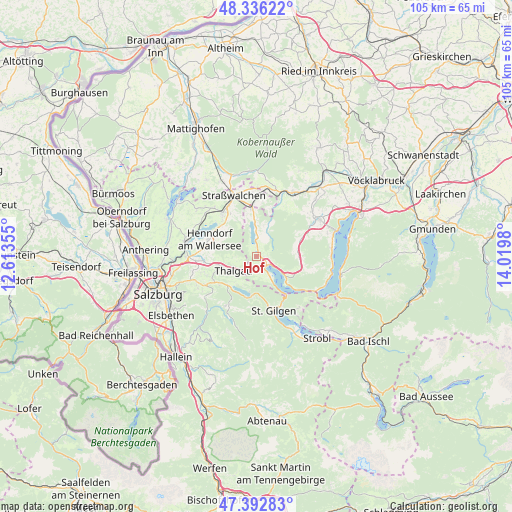
Hof GPS coordinates[2]
47° 52' 0.012" North, 13° 19' 0.012" East
| Map corner | latitude | longitude |
|---|---|---|
| Upper-left | 48.33622°, | 12.61355° |
| Center: | 47.86667°, | 13.31667° |
| Lower-right: | 47.39283°, | 14.0198° |
| Map W x H: | 104.9×104.9 km | = 65.2×65.2mi |
| max Lat: | 48.98333° ⇑40.6% North |
| Hof: | 47.86667° |
| min Lat: | ⇓59.4% South 46.48841° |
| min Long | Hof | max Long |
| 9.57802° | 13.31667° | 17.1° |
| W 22.3%⇐ | ⇒77.7% E |
Elevation
Elevation of Hof is 539 m = 1768 ft, and this is 33.5 m = 110 ft above average elevation for this country.
| Max E: |
2140 m = 7021 ft | 36.9% |
| Hof | 539 m 1768 ft | |
| Avg. | 505.5 m = 1658 ft | |
Min E: |
118 m = 387 ft | 63.1% |
See also: Austria elevation on elevation.city.
Geographical zone
Hof is located in North temperate zone (between Tropic of Cancer and the Arctic Circle). Distance of this North polar circle is 2078.9 km =1291.8 mi to North.| Distance of | km | miles | from Hof |
|---|---|---|---|
| North Pole | 4684.8 | 2911 | to North |
| Arctic Circle | 2078.9 | 1291.8 | to North |
| Tropic Cancer | 2716.4 | 1687.9 | to South |
| Equator | 5322.3 | 3307.1 | to South |


Nearby cities:
15 places around Hof: (largest is in red/bold)
• Enzersberg
8.9 km =5.5 mi,  257°
257°
• Fuschl am See
7.5 km =4.7 mi,  189°
189°
• Gaisberg
2.3 km =1.4 mi,  138°
138°
• Guggenberg
2.2 km =1.4 mi,  33°
33°
• Hof bei Salzburg
9.2 km =5.7 mi,  235°
235°
• Innerschwand
7.2 km =4.5 mi,  120°
120°
• Keuschen
3.9 km =2.4 mi,  198°
198°
• Mondsee
2.7 km =1.7 mi, 115°
• Oberwang
8.7 km =5.4 mi,  90°
90°
• Sankt Lorenz
4.5 km =2.8 mi,  148°
148°
• Thalgau
5.5 km =3.4 mi, 239°
• Thalgauberg
4.2 km =2.6 mi, 256°
• Tiefgraben
1.1 km =0.7 mi,  314°
314°
• Unterdorf
7.1 km =4.4 mi,  249°
249°
• Zell am Moos
3.7 km =2.3 mi,  0°
0°
Sources, notices
• [Note1] Compared only with cities in Austria existing in our database
• [Src1] Map data: © OpenStreetMap contributors (CC-BY-SA)
• [Src2] Other city data from geonames.org with taken over terms of usage.
• [Src3] Geographical zone / Annual Mean Temperature by Robert A. Rohde @ Wikipedia
