Unterdorf geodata
Unterdorf (Salzburg) is a populated place; located in Austria in Europe/Vienna (GMT+2) time zone. With population of 996 people, there are 1296 cities with bigger population in this country. Compared to other cities in Austria, 58.7% of cities are located further ↓South; 78.6% of cities are located further →East and 67.3% of cities have lower elevation than Unterdorf. Note1
Administrative division(s):
- Level 1: Salzburg
- Level 2: Politischer Bezirk Salzburg-Umgebung
- Level 3: Thalgau


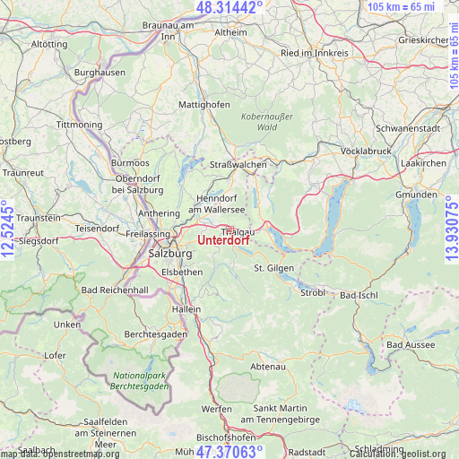
Unterdorf GPS coordinates[2]
47° 50' 40.812" North, 13° 13' 39.432" East
| Map corner | latitude | longitude |
|---|---|---|
| Upper-left | 48.31442°, | 12.5245° |
| Center: | 47.84467°, | 13.22762° |
| Lower-right: | 47.37063°, | 13.93075° |
| Map W x H: | 104.9×104.9 km | = 65.2×65.2mi |
| max Lat: | 48.98333° ⇑41.3% North |
| Unterdorf: | 47.84467° |
| min Lat: | ⇓58.7% South 46.48841° |
| min Long | Unterdorf | max Long |
| 9.57802° | 13.22762° | 17.1° |
| W 21.4%⇐ | ⇒78.6% E |
Elevation
Elevation of Unterdorf is 567 m = 1860 ft, and this is 61.5 m = 202 ft above average elevation for this country.
| Max E: |
2140 m = 7021 ft | 32.7% |
| Unterdorf | 567 m 1860 ft | |
| Avg. | 505.5 m = 1658 ft | |
Min E: |
118 m = 387 ft | 67.3% |
See also: Austria elevation on elevation.city.
Geographical zone
Unterdorf is located in North temperate zone (between Tropic of Cancer and the Arctic Circle). Distance of this North polar circle is 2081.3 km =1293.3 mi to North.| Distance of | km | miles | from Unterdorf |
|---|---|---|---|
| North Pole | 4687.2 | 2912.5 | to North |
| Arctic Circle | 2081.3 | 1293.3 | to North |
| Tropic Cancer | 2713.9 | 1686.3 | to South |
| Equator | 5319.8 | 3305.6 | to South |


Nearby cities:
15 places around Unterdorf: (largest is in red/bold)
• Ebenau
7.2 km =4.5 mi,  213°
213°
• Enzersberg
2.1 km =1.3 mi,  286°
286°
• Habach
5.7 km =3.5 mi,  238°
238°
• Henndorf am Wallersee
7 km =4.3 mi,  331°
331°
• Hof
7.1 km =4.4 mi,  69°
69°
• Hof bei Salzburg
3 km =1.9 mi,  198°
198°
• Keuschen
5.5 km =3.4 mi,  103°
103°
• Koppl
6.7 km =4.2 mi,  232°
232°
• Plainfeld
3.5 km =2.2 mi,  249°
249°
• Reitberg
5.3 km =3.3 mi,  279°
279°
• Schwaighofen
6.9 km =4.3 mi,  257°
257°
• Thalgau
1.9 km =1.2 mi, 100°
• Thalgauberg
2.9 km =1.8 mi,  59°
59°
• Tiefgraben
6.7 km =4.2 mi, 60°
• Vorderschroffenau
5.9 km =3.7 mi, 210°
Sources, notices
• [Note1] Compared only with cities in Austria existing in our database
• [Src1] Map data: © OpenStreetMap contributors (CC-BY-SA)
• [Src2] Other city data from geonames.org with taken over terms of usage.
• [Src3] Geographical zone / Annual Mean Temperature by Robert A. Rohde @ Wikipedia
