Strallegg geodata
Strallegg (Styria) is a seat of a third-order administrative division; located in Austria in Europe/Vienna (GMT+2) time zone. With population of 911 people, there are 1409 cities with bigger population in this country. Compared to other cities in Austria, 58.9% of cities are located further ↑North; 72.9% of cities are located further ←West and 89.2% of cities have lower elevation than Strallegg. Note1


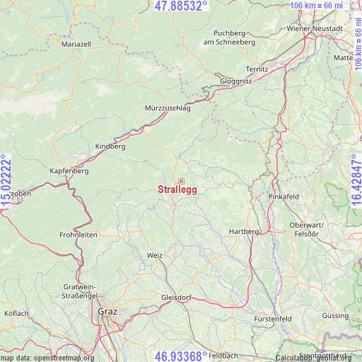
Strallegg GPS coordinates[2]
47° 24' 41.94" North, 15° 43' 31.224" East
| Map corner | latitude | longitude |
|---|---|---|
| Upper-left | 47.88532°, | 15.02222° |
| Center: | 47.41165°, | 15.72534° |
| Lower-right: | 46.93368°, | 16.42847° |
| Map W x H: | 105.8×105.8 km | = 65.7×65.7mi |
| max Lat: | 48.98333° ⇑58.9% North |
| Strallegg: | 47.41165° |
| min Lat: | ⇓41.1% South 46.48841° |
| min Long | Strallegg | max Long |
| 9.57802° | 15.72534° | 17.1° |
| W 72.9%⇐ | ⇒27.1% E |
Elevation
Elevation of Strallegg is 861 m = 2825 ft, and this is 355.5 m = 1166 ft above average elevation for this country.
| Max E: |
2140 m = 7021 ft | 10.8% |
| Strallegg | 861 m 2825 ft | |
| Avg. | 505.5 m = 1658 ft | |
Min E: |
118 m = 387 ft | 89.2% |
See also: Austria elevation on elevation.city.
Geographical zone
Strallegg is located in North temperate zone (between Tropic of Cancer and the Arctic Circle). Distance of this North polar circle is 2129.5 km =1323.2 mi to North.| Distance of | km | miles | from Strallegg |
|---|---|---|---|
| North Pole | 4735.4 | 2942.4 | to North |
| Arctic Circle | 2129.5 | 1323.2 | to North |
| Tropic Cancer | 2665.8 | 1656.5 | to South |
| Equator | 5271.7 | 3275.7 | to South |


Nearby cities:
15 places around Strallegg: (largest is in red/bold)
• Birkfeld
7.5 km =4.7 mi,  204°
204°
• Falkenstein
5.3 km =3.3 mi,  323°
323°
• Fischbach
6.6 km =4.1 mi,  300°
300°
• Gschaid bei Birkfeld
6.9 km =4.3 mi,  194°
194°
• Kirchenviertel
7.9 km =4.9 mi,  37°
37°
• Kirchenviertel
8.2 km =5.1 mi,  357°
357°
• Miesenbach bei Birkfeld
5.9 km =3.7 mi,  148°
148°
• Pittermann
4.4 km =2.7 mi,  82°
82°
• Prätis
9.8 km =6.1 mi,  138°
138°
• Ratten
8 km =5 mi, 355°
• Sankt Jakob im Walde
7.5 km =4.7 mi, 35°
• Sankt Kathrein am Hauenstein
9 km =5.6 mi,  344°
344°
• Schachen bei Vorau
10.6 km =6.6 mi,  109°
109°
• Vornholz
7.8 km =4.8 mi,  102°
102°
• Waisenegg
3.7 km =2.3 mi,  238°
238°
Sources, notices
• [Note1] Compared only with cities in Austria existing in our database
• [Src1] Map data: © OpenStreetMap contributors (CC-BY-SA)
• [Src2] Other city data from geonames.org with taken over terms of usage.
• [Src3] Geographical zone / Annual Mean Temperature by Robert A. Rohde @ Wikipedia
