Steyr geodata
Steyr (Upper Austria) is a seat of a third-order administrative division; located in Austria in Europe/Vienna (GMT+2) time zone. With population of 38,331 people, there are 17 cities with bigger population in this country. Compared to other cities in Austria, 68.9% of cities are located further ↓South; 55.2% of cities are located further →East and 77.8% of cities have higher elevation than Steyr. Note1


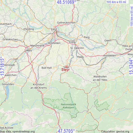
Steyr GPS coordinates[2]
48° 2' 33.864" North, 14° 25' 16.572" East
| Map corner | latitude | longitude |
|---|---|---|
| Upper-left | 48.51069°, | 13.71815° |
| Center: | 48.04274°, | 14.42127° |
| Lower-right: | 47.5705°, | 15.1244° |
| Map W x H: | 104.5×104.5 km | = 64.9×64.9mi |
| max Lat: | 48.98333° ⇑31.1% North |
| Steyr: | 48.04274° |
| min Lat: | ⇓68.9% South 46.48841° |
| min Long | Steyr | max Long |
| 9.57802° | 14.42127° | 17.1° |
| W 44.8%⇐ | ⇒55.2% E |
Elevation
Elevation of Steyr is 285 m = 935 ft, and this is 220.5 m = 723 ft below average elevation for this country.
| Max E: |
2140 m = 7021 ft | 77.8% |
| Avg. | 505.5 m = 1658 ft | |
| Steyr | 285 m = 935 ft | |
Min E: |
118 m = 387 ft | 22.2% |
See also: Austria elevation on elevation.city.
Geographical zone
Steyr is located in North temperate zone (between Tropic of Cancer and the Arctic Circle). Distance of this North polar circle is 2059.3 km =1279.6 mi to North.| Distance of | km | miles | from Steyr |
|---|---|---|---|
| North Pole | 4665.2 | 2898.8 | to North |
| Arctic Circle | 2059.3 | 1279.6 | to North |
| Tropic Cancer | 2735.9 | 1700 | to South |
| Equator | 5341.9 | 3319.3 | to South |


Nearby cities:
15 places around Steyr: (largest is in red/bold)
• Aschach an der Steyr
7.2 km =4.5 mi,  242°
242°
• Behamberg
5.4 km =3.4 mi,  122°
122°
• Dietach
5.3 km =3.3 mi,  356°
356°
• Dietachdorf
4.6 km =2.9 mi,  6°
6°
• Garsten
2.5 km =1.6 mi,  204°
204°
• Haidershofen
4.7 km =2.9 mi,  38°
38°
• Kleinraming
6.6 km =4.1 mi,  135°
135°
• Lahrndorf
6.2 km =3.9 mi,  209°
209°
• Neuzeug
6.6 km =4.1 mi,  277°
277°
• Penz
4.7 km =2.9 mi,  102°
102°
• Sankt Ulrich bei Steyr
2.7 km =1.7 mi,  154°
154°
• Sierning
8.3 km =5.2 mi,  270°
270°
• Unterwald
4.4 km =2.7 mi,  130°
130°
• Wanzenöd
4.2 km =2.6 mi,  78°
78°
• Wolfern
5.8 km =3.6 mi,  320°
320°
Sources, notices
• [Note1] Compared only with cities in Austria existing in our database
• [Src1] Map data: © OpenStreetMap contributors (CC-BY-SA)
• [Src2] Other city data from geonames.org with taken over terms of usage.
• [Src3] Geographical zone / Annual Mean Temperature by Robert A. Rohde @ Wikipedia
