Garsten geodata
Garsten (Upper Austria) is a seat of a third-order administrative division; located in Austria in Europe/Vienna (GMT+2) time zone. With population of 2,284 people, there are 532 cities with bigger population in this country. Compared to other cities in Austria, 67.9% of cities are located further ↓South; 55.6% of cities are located further →East and 76.4% of cities have higher elevation than Garsten. Note1
Administrative division(s):
- Level 1: Upper Austria
- Level 2: Politischer Bezirk Steyr-Land
- Level 3: Garsten


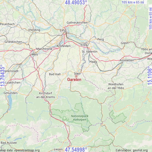
Garsten GPS coordinates[2]
48° 1' 20.64" North, 14° 24' 26.892" East
| Map corner | latitude | longitude |
|---|---|---|
| Upper-left | 48.49053°, | 13.70435° |
| Center: | 48.0224°, | 14.40747° |
| Lower-right: | 47.54998°, | 15.1106° |
| Map W x H: | 104.6×104.6 km | = 65×65mi |
| max Lat: | 48.98333° ⇑32.1% North |
| Garsten: | 48.0224° |
| min Lat: | ⇓67.9% South 46.48841° |
| min Long | Garsten | max Long |
| 9.57802° | 14.40747° | 17.1° |
| W 44.4%⇐ | ⇒55.6% E |
Elevation
Elevation of Garsten is 294 m = 965 ft, and this is 211.5 m = 694 ft below average elevation for this country.
| Max E: |
2140 m = 7021 ft | 76.4% |
| Avg. | 505.5 m = 1658 ft | |
| Garsten | 294 m = 965 ft | |
Min E: |
118 m = 387 ft | 23.6% |
See also: Austria elevation on elevation.city.
Geographical zone
Garsten is located in North temperate zone (between Tropic of Cancer and the Arctic Circle). Distance of this North polar circle is 2061.6 km =1281 mi to North.| Distance of | km | miles | from Garsten |
|---|---|---|---|
| North Pole | 4667.5 | 2900.2 | to North |
| Arctic Circle | 2061.6 | 1281 | to North |
| Tropic Cancer | 2733.7 | 1698.6 | to South |
| Equator | 5339.6 | 3317.9 | to South |


Nearby cities:
15 places around Garsten: (largest is in red/bold)
• Aschach an der Steyr
5.5 km =3.4 mi,  259°
259°
• Behamberg
5.7 km =3.5 mi,  96°
96°
• Dietach
7.6 km =4.7 mi,  5°
5°
• Dietachdorf
7 km =4.3 mi, 13°
• Haidershofen
7.2 km =4.5 mi,  33°
33°
• Kleinraming
6.2 km =3.9 mi,  113°
113°
• Lahrndorf
3.7 km =2.3 mi,  213°
213°
• Neuzeug
6.3 km =3.9 mi,  299°
299°
• Penz
5.8 km =3.6 mi,  77°
77°
• Sankt Ulrich bei Steyr
2.2 km =1.4 mi,  93°
93°
• Sierning
7.7 km =4.8 mi,  287°
287°
• Steyr
2.5 km =1.6 mi,  24°
24°
• Unterwald
4.4 km =2.7 mi, 98°
• Wanzenöd
6 km =3.7 mi,  59°
59°
• Wolfern
7.2 km =4.5 mi,  338°
338°
Sources, notices
• [Note1] Compared only with cities in Austria existing in our database
• [Src1] Map data: © OpenStreetMap contributors (CC-BY-SA)
• [Src2] Other city data from geonames.org with taken over terms of usage.
• [Src3] Geographical zone / Annual Mean Temperature by Robert A. Rohde @ Wikipedia
