Behamberg geodata
Behamberg (Lower Austria) is a seat of a third-order administrative division; located in Austria in Europe/Vienna (GMT+2) time zone. In our database, there are 2958 cities with bigger population. Compared to other cities in Austria, 67.2% of cities are located further ↓South; 53.6% of cities are located further →East and 66.1% of cities have higher elevation than Behamberg. Note1
Administrative division(s):
- Level 1: Lower Austria
- Level 2: Politischer Bezirk Amstetten
- Level 3: Behamberg


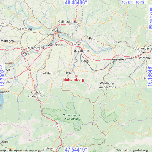
Behamberg GPS coordinates[2]
48° 1' 0.012" North, 14° 28' 59.988" East
| Map corner | latitude | longitude |
|---|---|---|
| Upper-left | 48.48486°, | 13.78021° |
| Center: | 48.01667°, | 14.48333° |
| Lower-right: | 47.54419°, | 15.18646° |
| Map W x H: | 104.6×104.6 km | = 65×65mi |
| max Lat: | 48.98333° ⇑32.8% North |
| Behamberg: | 48.01667° |
| min Lat: | ⇓67.2% South 46.48841° |
| min Long | Behamberg | max Long |
| 9.57802° | 14.48333° | 17.1° |
| W 46.4%⇐ | ⇒53.6% E |
Elevation
Elevation of Behamberg is 348 m = 1142 ft, and this is 157.5 m = 517 ft below average elevation for this country.
| Max E: |
2140 m = 7021 ft | 66.1% |
| Avg. | 505.5 m = 1658 ft | |
| Behamberg | 348 m = 1142 ft | |
Min E: |
118 m = 387 ft | 33.9% |
See also: Austria elevation on elevation.city.
Geographical zone
Behamberg is located in North temperate zone (between Tropic of Cancer and the Arctic Circle). Distance of this North polar circle is 2062.2 km =1281.4 mi to North.| Distance of | km | miles | from Behamberg |
|---|---|---|---|
| North Pole | 4668.1 | 2900.6 | to North |
| Arctic Circle | 2062.2 | 1281.4 | to North |
| Tropic Cancer | 2733 | 1698.2 | to South |
| Equator | 5339 | 3317.5 | to South |


Nearby cities:
15 places around Behamberg: (largest is in red/bold)
• Dietach
9.6 km =6 mi,  328°
328°
• Dietachdorf
8.5 km =5.3 mi, 331°
• Garsten
5.7 km =3.5 mi,  276°
276°
• Haidershofen
6.8 km =4.2 mi,  346°
346°
• Kleinraming
1.9 km =1.2 mi,  180°
180°
• Kürnberg
4.2 km =2.6 mi,  116°
116°
• Lahrndorf
8.1 km =5 mi,  252°
252°
• Laussa
7.8 km =4.8 mi,  198°
198°
• Penz
1.9 km =1.2 mi,  0°
0°
• Sankt Michael am Bruckbach
8.7 km =5.4 mi,  90°
90°
• Sankt Ulrich bei Steyr
3.5 km =2.2 mi, 278°
• Steyr
5.4 km =3.4 mi,  302°
302°
• Unterwald
1.2 km =0.7 mi,  270°
270°
• Wanzenöd
3.7 km =2.3 mi, 352°
• Weistrach
8.3 km =5.2 mi,  63°
63°
Sources, notices
• [Note1] Compared only with cities in Austria existing in our database
• [Src1] Map data: © OpenStreetMap contributors (CC-BY-SA)
• [Src2] Other city data from geonames.org with taken over terms of usage.
• [Src3] Geographical zone / Annual Mean Temperature by Robert A. Rohde @ Wikipedia
