Wolfern geodata
Wolfern (Upper Austria) is a seat of a third-order administrative division; located in Austria in Europe/Vienna (GMT+2) time zone. With population of 2,374 people, there are 516 cities with bigger population in this country. Compared to other cities in Austria, 71.6% of cities are located further ↓South; 56.2% of cities are located further →East and 63.4% of cities have higher elevation than Wolfern. Note1
Administrative division(s):
- Level 1: Upper Austria
- Level 2: Politischer Bezirk Steyr-Land
- Level 3: Wolfern


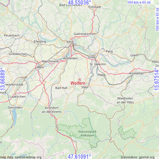
Wolfern GPS coordinates[2]
48° 4' 58.008" North, 14° 22' 19.236" East
| Map corner | latitude | longitude |
|---|---|---|
| Upper-left | 48.55036°, | 13.66889° |
| Center: | 48.08278°, | 14.37201° |
| Lower-right: | 47.61091°, | 15.07514° |
| Map W x H: | 104.5×104.5 km | = 64.9×64.9mi |
| max Lat: | 48.98333° ⇑28.4% North |
| Wolfern: | 48.08278° |
| min Lat: | ⇓71.6% South 46.48841° |
| min Long | Wolfern | max Long |
| 9.57802° | 14.37201° | 17.1° |
| W 43.8%⇐ | ⇒56.2% E |
Elevation
Elevation of Wolfern is 361 m = 1184 ft, and this is 144.5 m = 474 ft below average elevation for this country.
| Max E: |
2140 m = 7021 ft | 63.4% |
| Avg. | 505.5 m = 1658 ft | |
| Wolfern | 361 m = 1184 ft | |
Min E: |
118 m = 387 ft | 36.6% |
See also: Austria elevation on elevation.city.
Geographical zone
Wolfern is located in North temperate zone (between Tropic of Cancer and the Arctic Circle). Distance of this North polar circle is 2054.9 km =1276.9 mi to North.| Distance of | km | miles | from Wolfern |
|---|---|---|---|
| North Pole | 4660.8 | 2896.1 | to North |
| Arctic Circle | 2054.9 | 1276.9 | to North |
| Tropic Cancer | 2740.4 | 1702.8 | to South |
| Equator | 5346.3 | 3322 | to South |


Nearby cities:
15 places around Wolfern: (largest is in red/bold)
• Aschach an der Steyr
8.2 km =5.1 mi,  199°
199°
• Dietach
3.4 km =2.1 mi,  76°
76°
• Dietachdorf
4.2 km =2.6 mi,  88°
88°
• Garsten
7.2 km =4.5 mi,  158°
158°
• Haidershofen
6.7 km =4.2 mi,  96°
96°
• Hofkirchen im Traunkreis
6.7 km =4.2 mi,  3°
3°
• Kronstorf
9.5 km =5.9 mi,  45°
45°
• Losensteinleithen
3.8 km =2.4 mi,  343°
343°
• Neuzeug
4.6 km =2.9 mi,  218°
218°
• Niederneukirchen
9 km =5.6 mi, 344°
• Sankt Ulrich bei Steyr
8.4 km =5.2 mi,  144°
144°
• Sierning
6.4 km =4 mi,  226°
226°
• Steyr
5.8 km =3.6 mi, 140°
• Wanzenöd
8.6 km =5.3 mi,  115°
115°
• Weichstetten
5.7 km =3.5 mi,  318°
318°
Sources, notices
• [Note1] Compared only with cities in Austria existing in our database
• [Src1] Map data: © OpenStreetMap contributors (CC-BY-SA)
• [Src2] Other city data from geonames.org with taken over terms of usage.
• [Src3] Geographical zone / Annual Mean Temperature by Robert A. Rohde @ Wikipedia
