Sölden geodata
Sölden (Tyrol) is a seat of a third-order administrative division; located in Austria in Europe/Vienna (GMT+2) time zone. With population of 2,205 people, there are 552 cities with bigger population in this country. Compared to other cities in Austria, 85.6% of cities are located further ↑North; 93.6% of cities are located further →East and 99.8% of cities have lower elevation than Sölden. Note1


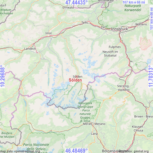
Sölden GPS coordinates[2]
46° 58' 0.012" North, 11° 0' 0" East
| Map corner | latitude | longitude |
|---|---|---|
| Upper-left | 47.44435°, | 10.29688° |
| Center: | 46.96667°, | 11° |
| Lower-right: | 46.48469°, | 11.70313° |
| Map W x H: | 106.7×106.7 km | = 66.3×66.3mi |
| max Lat: | 48.98333° ⇑85.6% North |
| Sölden: | 46.96667° |
| min Lat: | ⇓14.4% South 46.48841° |
| min Long | Sölden | max Long |
| 9.57802° | 11° | 17.1° |
| W 6.4%⇐ | ⇒93.6% E |
Elevation
Elevation of Sölden is 1526 m = 5007 ft, and this is 1020.5 m = 3348 ft above average elevation for this country.
| Max E: |
2140 m = 7021 ft | 0.2% |
| Sölden | 1526 m 5007 ft | |
| Avg. | 505.5 m = 1658 ft | |
Min E: |
118 m = 387 ft | 99.8% |
See also: Austria elevation on elevation.city.
Geographical zone
Sölden is located in North temperate zone (between Tropic of Cancer and the Arctic Circle). Distance of this North polar circle is 2179 km =1354 mi to North.| Distance of | km | miles | from Sölden |
|---|---|---|---|
| North Pole | 4784.9 | 2973.2 | to North |
| Arctic Circle | 2179 | 1354 | to North |
| Tropic Cancer | 2616.3 | 1625.7 | to South |
| Equator | 5222.2 | 3244.9 | to South |


Nearby cities:
15 places around Sölden: (largest is in red/bold)
• Fendels
26.3 km =16.3 mi,  291°
291°
• Gries im Sellrain
28.1 km =17.5 mi,  24°
24°
• Gschnitz
28 km =17.4 mi,  71°
71°
• Gurgl
10.2 km =6.3 mi,  165°
165°
• Jerzens
28.1 km =17.5 mi,  316°
316°
• Kaunertal
20.5 km =12.7 mi, 290°
• Kauns
26.4 km =16.4 mi,  297°
297°
• Längenfeld
12.2 km =7.6 mi,  349°
349°
• Oetz
27 km =16.8 mi,  343°
343°
• Prutz
28.4 km =17.6 mi, 297°
• Ried im Oberinntal
28.1 km =17.5 mi, 289°
• Sankt Leonhard im Pitztal
15.9 km =9.9 mi,  314°
314°
• Sautens
27.8 km =17.3 mi, 338°
• Tumpen
23.5 km =14.6 mi, 341°
• Umhausen
19.5 km =12.1 mi, 343°
Sources, notices
• [Note1] Compared only with cities in Austria existing in our database
• [Src1] Map data: © OpenStreetMap contributors (CC-BY-SA)
• [Src2] Other city data from geonames.org with taken over terms of usage.
• [Src3] Geographical zone / Annual Mean Temperature by Robert A. Rohde @ Wikipedia
