Fendels geodata
Fendels (Tyrol) is a seat of a third-order administrative division; located in Austria in Europe/Vienna (GMT+2) time zone. With population of 259 people, there are 2794 cities with bigger population in this country. Compared to other cities in Austria, 81.8% of cities are located further ↑North; 95% of cities are located further →East and 99.2% of cities have lower elevation than Fendels. Note1


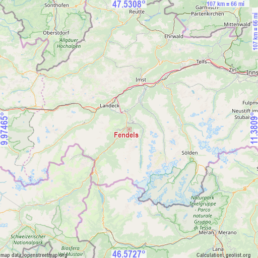
Fendels GPS coordinates[2]
47° 3' 14.04" North, 10° 40' 39.972" East
| Map corner | latitude | longitude |
|---|---|---|
| Upper-left | 47.5308°, | 9.97465° |
| Center: | 47.0539°, | 10.67777° |
| Lower-right: | 46.5727°, | 11.3809° |
| Map W x H: | 106.5×106.5 km | = 66.2×66.2mi |
| max Lat: | 48.98333° ⇑81.8% North |
| Fendels: | 47.0539° |
| min Lat: | ⇓18.2% South 46.48841° |
| min Long | Fendels | max Long |
| 9.57802° | 10.67777° | 17.1° |
| W 5%⇐ | ⇒95% E |
Elevation
Elevation of Fendels is 1372 m = 4501 ft, and this is 866.5 m = 2843 ft above average elevation for this country.
| Max E: |
2140 m = 7021 ft | 0.8% |
| Fendels | 1372 m 4501 ft | |
| Avg. | 505.5 m = 1658 ft | |
Min E: |
118 m = 387 ft | 99.2% |
See also: Austria elevation on elevation.city.
Geographical zone
Fendels is located in North temperate zone (between Tropic of Cancer and the Arctic Circle). Distance of this North polar circle is 2169.3 km =1347.9 mi to North.| Distance of | km | miles | from Fendels |
|---|---|---|---|
| North Pole | 4775.2 | 2967.2 | to North |
| Arctic Circle | 2169.3 | 1347.9 | to North |
| Tropic Cancer | 2626 | 1631.7 | to South |
| Equator | 5231.9 | 3251 | to South |


Nearby cities:
15 places around Fendels: (largest is in red/bold)
• Fiss
4.6 km =2.9 mi,  274°
274°
• Fliess
8.4 km =5.2 mi,  326°
326°
• Jerzens
12 km =7.5 mi,  25°
25°
• Kaunertal
5.8 km =3.6 mi,  116°
116°
• Kauns
2.9 km =1.8 mi,  21°
21°
• Ladis
3.1 km =1.9 mi,  317°
317°
• Landeck
12.8 km =8 mi, 318°
• Pfunds
13.7 km =8.5 mi,  224°
224°
• Prutz
3.4 km =2.1 mi,  345°
345°
• Ried im Oberinntal
2.1 km =1.3 mi,  258°
258°
• Sankt Leonhard im Pitztal
13.1 km =8.1 mi,  83°
83°
• Serfaus
5.8 km =3.6 mi,  254°
254°
• Tösens
6.7 km =4.2 mi,  233°
233°
• Wenns
13.2 km =8.2 mi, 18°
• Zams
13.4 km =8.3 mi, 330°
Sources, notices
• [Note1] Compared only with cities in Austria existing in our database
• [Src1] Map data: © OpenStreetMap contributors (CC-BY-SA)
• [Src2] Other city data from geonames.org with taken over terms of usage.
• [Src3] Geographical zone / Annual Mean Temperature by Robert A. Rohde @ Wikipedia
