Kaunertal geodata
Kaunertal (Tyrol) is a populated place; located in Austria in Europe/Vienna (GMT+2) time zone. With population of 597 people, there are 2151 cities with bigger population in this country. Compared to other cities in Austria, 82.9% of cities are located further ↑North; 94.6% of cities are located further →East and 99.8% of cities have lower elevation than Kaunertal. Note1


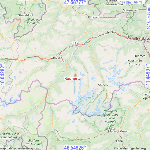
Kaunertal GPS coordinates[2]
47° 1' 50.412" North, 10° 44' 45.384" East
| Map corner | latitude | longitude |
|---|---|---|
| Upper-left | 47.50777°, | 10.04282° |
| Center: | 47.03067°, | 10.74594° |
| Lower-right: | 46.54926°, | 11.44907° |
| Map W x H: | 106.6×106.6 km | = 66.2×66.2mi |
| max Lat: | 48.98333° ⇑82.9% North |
| Kaunertal: | 47.03067° |
| min Lat: | ⇓17.1% South 46.48841° |
| min Long | Kaunertal | max Long |
| 9.57802° | 10.74594° | 17.1° |
| W 5.4%⇐ | ⇒94.6% E |
Elevation
Elevation of Kaunertal is 1581 m = 5187 ft, and this is 1075.5 m = 3529 ft above average elevation for this country.
| Max E: |
2140 m = 7021 ft | 0.2% |
| Kaunertal | 1581 m 5187 ft | |
| Avg. | 505.5 m = 1658 ft | |
Min E: |
118 m = 387 ft | 99.8% |
See also: Austria elevation on elevation.city.
Geographical zone
Kaunertal is located in North temperate zone (between Tropic of Cancer and the Arctic Circle). Distance of this North polar circle is 2171.9 km =1349.6 mi to North.| Distance of | km | miles | from Kaunertal |
|---|---|---|---|
| North Pole | 4777.7 | 2968.7 | to North |
| Arctic Circle | 2171.9 | 1349.6 | to North |
| Tropic Cancer | 2623.4 | 1630.1 | to South |
| Equator | 5229.3 | 3249.3 | to South |


Nearby cities:
15 places around Kaunertal: (largest is in red/bold)
• Fendels
5.8 km =3.6 mi,  296°
296°
• Fiss
10.2 km =6.3 mi,  286°
286°
• Fliess
13.7 km =8.5 mi,  314°
314°
• Jerzens
13.4 km =8.3 mi,  0°
0°
• Kauns
6.7 km =4.2 mi,  322°
322°
• Ladis
8.8 km =5.5 mi, 303°
• Längenfeld
17.6 km =10.9 mi,  74°
74°
• Pfunds
16.5 km =10.3 mi,  244°
244°
• Prutz
8.4 km =5.2 mi, 314°
• Ried im Oberinntal
7.6 km =4.7 mi, 286°
• Sankt Leonhard im Pitztal
8.8 km =5.5 mi,  63°
63°
• Serfaus
10.9 km =6.8 mi,  275°
275°
• Tösens
10.6 km =6.6 mi,  262°
262°
• Umhausen
18 km =11.2 mi,  49°
49°
• Wenns
15.2 km =9.4 mi,  356°
356°
Sources, notices
• [Note1] Compared only with cities in Austria existing in our database
• [Src1] Map data: © OpenStreetMap contributors (CC-BY-SA)
• [Src2] Other city data from geonames.org with taken over terms of usage.
• [Src3] Geographical zone / Annual Mean Temperature by Robert A. Rohde @ Wikipedia
