Arbing geodata
Arbing (Upper Austria) is a populated place; located in Austria in Europe/Vienna (GMT+2) time zone. With population of 746 people, there are 1733 cities with bigger population in this country. Compared to other cities in Austria, 81.4% of cities are located further ↓South; 50.3% of cities are located further →East and 84.2% of cities have higher elevation than Arbing. Note1


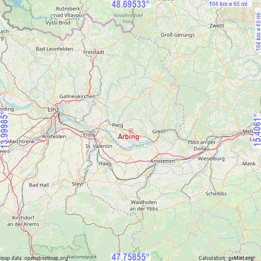
Arbing GPS coordinates[2]
48° 13' 44.688" North, 14° 42' 10.692" East
| Map corner | latitude | longitude |
|---|---|---|
| Upper-left | 48.69533°, | 13.99985° |
| Center: | 48.22908°, | 14.70297° |
| Lower-right: | 47.75855°, | 15.4061° |
| Map W x H: | 104.2×104.2 km | = 64.7×64.7mi |
| max Lat: | 48.98333° ⇑18.6% North |
| Arbing: | 48.22908° |
| min Lat: | ⇓81.4% South 46.48841° |
| min Long | Arbing | max Long |
| 9.57802° | 14.70297° | 17.1° |
| W 49.7%⇐ | ⇒50.3% E |
Elevation
Elevation of Arbing is 251 m = 823 ft, and this is 254.5 m = 835 ft below average elevation for this country.
| Max E: |
2140 m = 7021 ft | 84.2% |
| Avg. | 505.5 m = 1658 ft | |
| Arbing | 251 m = 823 ft | |
Min E: |
118 m = 387 ft | 15.8% |
See also: Austria elevation on elevation.city.
Geographical zone
Arbing is located in North temperate zone (between Tropic of Cancer and the Arctic Circle). Distance of this North polar circle is 2038.6 km =1266.7 mi to North.| Distance of | km | miles | from Arbing |
|---|---|---|---|
| North Pole | 4644.5 | 2886 | to North |
| Arctic Circle | 2038.6 | 1266.7 | to North |
| Tropic Cancer | 2756.7 | 1712.9 | to South |
| Equator | 5362.6 | 3332.2 | to South |


Nearby cities:
15 places around Arbing: (largest is in red/bold)
• Allerheiligen im Mühlkreis
9 km =5.6 mi,  334°
334°
• Au an der Donau
8.9 km =5.5 mi,  269°
269°
• Bad Kreuzen
8.8 km =5.5 mi,  60°
60°
• Baumgartenberg
3.8 km =2.4 mi,  126°
126°
• Limbach
9.5 km =5.9 mi,  201°
201°
• Mitterkirchen im Machland
4.6 km =2.9 mi,  186°
186°
• Münzbach
4.3 km =2.7 mi,  7°
7°
• Naarn im Machlande
7 km =4.3 mi, 266°
• Perg
5.7 km =3.5 mi,  294°
294°
• Sankt Pantaleon
10.2 km =6.3 mi,  258°
258°
• Saxen
6.9 km =4.3 mi,  109°
109°
• Schwertberg
10 km =6.2 mi,  299°
299°
• Strengberg
9.9 km =6.2 mi, 202°
• Wallsee
7 km =4.3 mi,  171°
171°
• Windhaag bei Perg
6.5 km =4 mi,  345°
345°
Sources, notices
• [Note1] Compared only with cities in Austria existing in our database
• [Src1] Map data: © OpenStreetMap contributors (CC-BY-SA)
• [Src2] Other city data from geonames.org with taken over terms of usage.
• [Src3] Geographical zone / Annual Mean Temperature by Robert A. Rohde @ Wikipedia
