Bad Kreuzen geodata
Bad Kreuzen (Upper Austria) is a seat of a third-order administrative division; located in Austria in Europe/Vienna (GMT+2) time zone. With population of 684 people, there are 1893 cities with bigger population in this country. Compared to other cities in Austria, 83.9% of cities are located further ↓South; 51.6% of cities are located further ←West and 53.6% of cities have lower elevation than Bad Kreuzen. Note1
Administrative division(s):
- Level 1: Upper Austria
- Level 2: Politischer Bezirk Perg
- Level 3: Bad Kreuzen


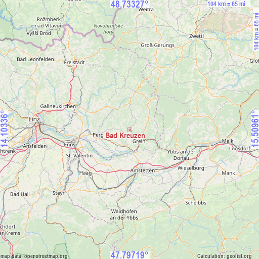
Bad Kreuzen GPS coordinates[2]
48° 16' 2.532" North, 14° 48' 23.328" East
| Map corner | latitude | longitude |
|---|---|---|
| Upper-left | 48.73327°, | 14.10336° |
| Center: | 48.26737°, | 14.80648° |
| Lower-right: | 47.79719°, | 15.50961° |
| Map W x H: | 104.1×104.1 km | = 64.7×64.7mi |
| max Lat: | 48.98333° ⇑16.1% North |
| Bad Kreuzen: | 48.26737° |
| min Lat: | ⇓83.9% South 46.48841° |
| min Long | Bad Kreuzen | max Long |
| 9.57802° | 14.80648° | 17.1° |
| W 51.6%⇐ | ⇒48.4% E |
Elevation
Elevation of Bad Kreuzen is 475 m = 1558 ft, and this is 30.5 m = 100 ft below average elevation for this country.
| Max E: |
2140 m = 7021 ft | 46.4% |
| Avg. | 505.5 m = 1658 ft | |
| Bad Kreuzen | 475 m = 1558 ft | |
Min E: |
118 m = 387 ft | 53.6% |
See also: Austria elevation on elevation.city.
Geographical zone
Bad Kreuzen is located in North temperate zone (between Tropic of Cancer and the Arctic Circle). Distance of this North polar circle is 2034.3 km =1264.1 mi to North.| Distance of | km | miles | from Bad Kreuzen |
|---|---|---|---|
| North Pole | 4640.2 | 2883.3 | to North |
| Arctic Circle | 2034.3 | 1264.1 | to North |
| Tropic Cancer | 2760.9 | 1715.5 | to South |
| Equator | 5366.8 | 3334.8 | to South |


Nearby cities:
15 places around Bad Kreuzen: (largest is in red/bold)
• Arbing
8.8 km =5.5 mi,  240°
240°
• Ardagger Markt
11.2 km =7 mi,  176°
176°
• Baumgartenberg
8 km =5 mi,  215°
215°
• Grein
5.8 km =3.6 mi,  138°
138°
• Kollmitzberg
11.7 km =7.3 mi,  163°
163°
• Mitterkirchen im Machland
12 km =7.5 mi, 222°
• Mönchdorf
10.4 km =6.5 mi,  355°
355°
• Münzbach
7.1 km =4.4 mi,  270°
270°
• Neustadtl-Markt
10.9 km =6.8 mi, 139°
• Oed
10.9 km =6.8 mi,  148°
148°
• Pabneukirchen
6.3 km =3.9 mi,  7°
7°
• Pierbach
9.7 km =6 mi,  337°
337°
• Saxen
6.7 km =4.2 mi,  190°
190°
• Waldhausen im Strudengau
10.5 km =6.5 mi,  86°
86°
• Windhaag bei Perg
9.5 km =5.9 mi,  282°
282°
Sources, notices
• [Note1] Compared only with cities in Austria existing in our database
• [Src1] Map data: © OpenStreetMap contributors (CC-BY-SA)
• [Src2] Other city data from geonames.org with taken over terms of usage.
• [Src3] Geographical zone / Annual Mean Temperature by Robert A. Rohde @ Wikipedia
