Sankt Gallen geodata
Sankt Gallen (Styria) is a seat of a third-order administrative division; located in Austria in Europe/Vienna (GMT+2) time zone. With population of 792 people, there are 1632 cities with bigger population in this country. Compared to other cities in Austria, 52.9% of cities are located further ↓South; 51.4% of cities are located further →East and 59.7% of cities have lower elevation than Sankt Gallen. Note1
Administrative division(s):
- Level 1: Styria
- Level 2: Politischer Bezirk Liezen
- Level 3: Sankt Gallen


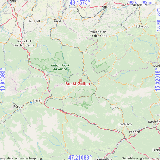
Sankt Gallen GPS coordinates[2]
47° 41' 10.716" North, 14° 37' 1.38" East
| Map corner | latitude | longitude |
|---|---|---|
| Upper-left | 48.1575°, | 13.91393° |
| Center: | 47.68631°, | 14.61705° |
| Lower-right: | 47.21083°, | 15.32018° |
| Map W x H: | 105.3×105.3 km | = 65.4×65.4mi |
| max Lat: | 48.98333° ⇑47.1% North |
| Sankt Gallen: | 47.68631° |
| min Lat: | ⇓52.9% South 46.48841° |
| min Long | Sankt Gallen | max Long |
| 9.57802° | 14.61705° | 17.1° |
| W 48.6%⇐ | ⇒51.4% E |
Elevation
Elevation of Sankt Gallen is 516 m = 1693 ft, and this is 10.5 m = 34 ft above average elevation for this country.
| Max E: |
2140 m = 7021 ft | 40.3% |
| Sankt Gallen | 516 m 1693 ft | |
| Avg. | 505.5 m = 1658 ft | |
Min E: |
118 m = 387 ft | 59.7% |
See also: Austria elevation on elevation.city.
Geographical zone
Sankt Gallen is located in North temperate zone (between Tropic of Cancer and the Arctic Circle). Distance of this North polar circle is 2099 km =1304.3 mi to North.| Distance of | km | miles | from Sankt Gallen |
|---|---|---|---|
| North Pole | 4704.8 | 2923.4 | to North |
| Arctic Circle | 2099 | 1304.3 | to North |
| Tropic Cancer | 2696.3 | 1675.4 | to South |
| Equator | 5302.2 | 3294.6 | to South |


Nearby cities:
15 places around Sankt Gallen: (largest is in red/bold)
• Admont
17 km =10.6 mi,  223°
223°
• Altenmarkt bei Sankt Gallen
4.7 km =2.9 mi,  29°
29°
• Edlbach
20.6 km =12.8 mi,  278°
278°
• Gams bei Hieflau
12.6 km =7.8 mi,  99°
99°
• Hall bei Admont
15.9 km =9.9 mi,  226°
226°
• Hieflau
13.1 km =8.1 mi,  132°
132°
• Hollenstein an der Ybbs
17.5 km =10.9 mi,  41°
41°
• Johnsbach
17.2 km =10.7 mi,  188°
188°
• Kleinreifling
14.5 km =9 mi,  4°
4°
• Landl
9.2 km =5.7 mi,  110°
110°
• Lumplgraben
21 km =13 mi,  342°
342°
• Palfau
13.8 km =8.6 mi,  83°
83°
• Spital am Pyhrn
20.9 km =13 mi,  263°
263°
• Weng im Gesäuse
12.6 km =7.8 mi, 222°
• Weyer
19.3 km =12 mi,  10°
10°
Sources, notices
• [Note1] Compared only with cities in Austria existing in our database
• [Src1] Map data: © OpenStreetMap contributors (CC-BY-SA)
• [Src2] Other city data from geonames.org with taken over terms of usage.
• [Src3] Geographical zone / Annual Mean Temperature by Robert A. Rohde @ Wikipedia
