Palfau geodata
Palfau (Styria) is a seat of a third-order administrative division; located in Austria in Europe/Vienna (GMT+2) time zone. With population of 369 people, there are 2659 cities with bigger population in this country. Compared to other cities in Austria, 53.3% of cities are located further ↓South; 51.3% of cities are located further ←West and 69.6% of cities have lower elevation than Palfau. Note1


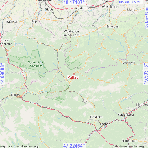
Palfau GPS coordinates[2]
47° 42' 0" North, 14° 48' 0" East
| Map corner | latitude | longitude |
|---|---|---|
| Upper-left | 48.17107°, | 14.09688° |
| Center: | 47.7°, | 14.8° |
| Lower-right: | 47.22464°, | 15.50313° |
| Map W x H: | 105.2×105.2 km | = 65.4×65.4mi |
| max Lat: | 48.98333° ⇑46.7% North |
| Palfau: | 47.7° |
| min Lat: | ⇓53.3% South 46.48841° |
| min Long | Palfau | max Long |
| 9.57802° | 14.8° | 17.1° |
| W 51.3%⇐ | ⇒48.7% E |
Elevation
Elevation of Palfau is 586 m = 1923 ft, and this is 80.5 m = 264 ft above average elevation for this country.
| Max E: |
2140 m = 7021 ft | 30.4% |
| Palfau | 586 m 1923 ft | |
| Avg. | 505.5 m = 1658 ft | |
Min E: |
118 m = 387 ft | 69.6% |
See also: Austria elevation on elevation.city.
Geographical zone
Palfau is located in North temperate zone (between Tropic of Cancer and the Arctic Circle). Distance of this North polar circle is 2097.4 km =1303.3 mi to North.| Distance of | km | miles | from Palfau |
|---|---|---|---|
| North Pole | 4703.3 | 2922.5 | to North |
| Arctic Circle | 2097.4 | 1303.3 | to North |
| Tropic Cancer | 2697.8 | 1676.3 | to South |
| Equator | 5303.7 | 3295.6 | to South |


Nearby cities:
15 places around Palfau: (largest is in red/bold)
• Altenmarkt bei Sankt Gallen
11.6 km =7.2 mi,  282°
282°
• Eisenerz
19.6 km =12.2 mi,  161°
161°
• Gaflenz
22.4 km =13.9 mi,  345°
345°
• Gams bei Hieflau
3.9 km =2.4 mi,  198°
198°
• Göstling an der Ybbs
15.7 km =9.8 mi,  41°
41°
• Hieflau
11.2 km =7 mi, 201°
• Hollenstein an der Ybbs
11.6 km =7.2 mi, 350°
• Johnsbach
24.6 km =15.3 mi,  221°
221°
• Kleinreifling
18 km =11.2 mi,  316°
316°
• Landl
7 km =4.3 mi,  226°
226°
• Opponitz
19.8 km =12.3 mi,  4°
4°
• Sankt Gallen
13.8 km =8.6 mi,  263°
263°
• Weng im Gesäuse
24.7 km =15.3 mi,  243°
243°
• Weyer
20.2 km =12.6 mi,  329°
329°
• Wildalpen
14.8 km =9.2 mi,  112°
112°
Sources, notices
• [Note1] Compared only with cities in Austria existing in our database
• [Src1] Map data: © OpenStreetMap contributors (CC-BY-SA)
• [Src2] Other city data from geonames.org with taken over terms of usage.
• [Src3] Geographical zone / Annual Mean Temperature by Robert A. Rohde @ Wikipedia
