Lumplgraben geodata
Lumplgraben (Upper Austria) is a populated place; located in Austria in Europe/Vienna (GMT+2) time zone. With population of 652 people, there are 1978 cities with bigger population in this country. Compared to other cities in Austria, 59.4% of cities are located further ↓South; 52.7% of cities are located further →East and 72.6% of cities have lower elevation than Lumplgraben. Note1
Administrative division(s):
- Level 1: Upper Austria
- Level 2: Politischer Bezirk Steyr-Land
- Level 3: Großraming


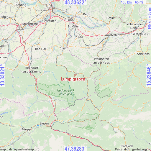
Lumplgraben GPS coordinates[2]
47° 52' 0.012" North, 14° 31' 59.988" East
| Map corner | latitude | longitude |
|---|---|---|
| Upper-left | 48.33622°, | 13.83021° |
| Center: | 47.86667°, | 14.53333° |
| Lower-right: | 47.39283°, | 15.23646° |
| Map W x H: | 104.9×104.9 km | = 65.2×65.2mi |
| max Lat: | 48.98333° ⇑40.6% North |
| Lumplgraben: | 47.86667° |
| min Lat: | ⇓59.4% South 46.48841° |
| min Long | Lumplgraben | max Long |
| 9.57802° | 14.53333° | 17.1° |
| W 47.3%⇐ | ⇒52.7% E |
Elevation
Elevation of Lumplgraben is 620 m = 2034 ft, and this is 114.5 m = 376 ft above average elevation for this country.
| Max E: |
2140 m = 7021 ft | 27.4% |
| Lumplgraben | 620 m 2034 ft | |
| Avg. | 505.5 m = 1658 ft | |
Min E: |
118 m = 387 ft | 72.6% |
See also: Austria elevation on elevation.city.
Geographical zone
Lumplgraben is located in North temperate zone (between Tropic of Cancer and the Arctic Circle). Distance of this North polar circle is 2078.9 km =1291.8 mi to North.| Distance of | km | miles | from Lumplgraben |
|---|---|---|---|
| North Pole | 4684.8 | 2911 | to North |
| Arctic Circle | 2078.9 | 1291.8 | to North |
| Tropic Cancer | 2716.4 | 1687.9 | to South |
| Equator | 5322.3 | 3307.1 | to South |


Nearby cities:
15 places around Lumplgraben: (largest is in red/bold)
• Arzberg
4.8 km =3 mi,  309°
309°
• Behamberg
17.1 km =10.6 mi,  347°
347°
• Ertl
14.3 km =8.9 mi,  30°
30°
• Gaflenz
14.6 km =9.1 mi,  77°
77°
• Grossraming
2.2 km =1.4 mi, 33°
• Kleinraming
15.3 km =9.5 mi, 345°
• Kleinreifling
9.3 km =5.8 mi,  126°
126°
• Konradsheim
16.5 km =10.3 mi,  55°
55°
• Kürnberg
14.8 km =9.2 mi,  0°
0°
• Laussa
11.2 km =7 mi,  326°
326°
• Losenstein
9.6 km =6 mi, 311°
• Maria Neustift
8.9 km =5.5 mi, 33°
• Reichraming
6.5 km =4 mi,  286°
286°
• Ternberg
15.7 km =9.8 mi,  303°
303°
• Weyer
9.8 km =6.1 mi,  96°
96°
Sources, notices
• [Note1] Compared only with cities in Austria existing in our database
• [Src1] Map data: © OpenStreetMap contributors (CC-BY-SA)
• [Src2] Other city data from geonames.org with taken over terms of usage.
• [Src3] Geographical zone / Annual Mean Temperature by Robert A. Rohde @ Wikipedia
