Landl geodata
Landl (Styria) is a seat of a third-order administrative division; located in Austria in Europe/Vienna (GMT+2) time zone. In our database, there are 2958 cities with bigger population. Compared to other cities in Austria, 52.1% of cities are located further ↓South; 50.1% of cities are located further ←West and 60.7% of cities have lower elevation than Landl. Note1


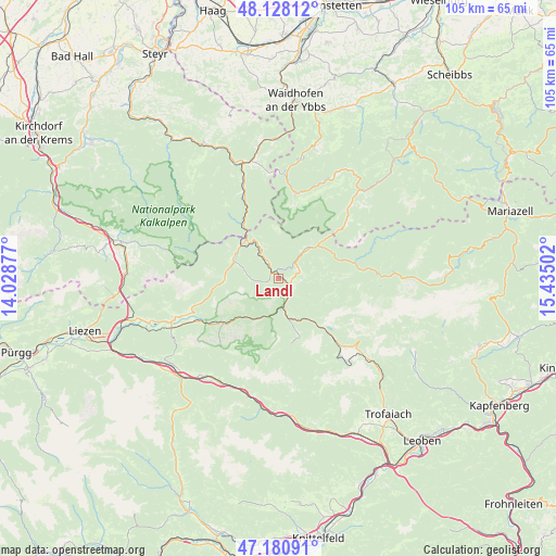
Landl GPS coordinates[2]
47° 39' 23.976" North, 14° 43' 54.804" East
| Map corner | latitude | longitude |
|---|---|---|
| Upper-left | 48.12812°, | 14.02877° |
| Center: | 47.65666°, | 14.73189° |
| Lower-right: | 47.18091°, | 15.43502° |
| Map W x H: | 105.3×105.3 km | = 65.4×65.4mi |
| max Lat: | 48.98333° ⇑47.9% North |
| Landl: | 47.65666° |
| min Lat: | ⇓52.1% South 46.48841° |
| min Long | Landl | max Long |
| 9.57802° | 14.73189° | 17.1° |
| W 50.1%⇐ | ⇒49.9% E |
Elevation
Elevation of Landl is 523 m = 1716 ft, and this is 17.5 m = 57 ft above average elevation for this country.
| Max E: |
2140 m = 7021 ft | 39.3% |
| Landl | 523 m 1716 ft | |
| Avg. | 505.5 m = 1658 ft | |
Min E: |
118 m = 387 ft | 60.7% |
See also: Austria elevation on elevation.city.
Geographical zone
Landl is located in North temperate zone (between Tropic of Cancer and the Arctic Circle). Distance of this North polar circle is 2102.3 km =1306.3 mi to North.| Distance of | km | miles | from Landl |
|---|---|---|---|
| North Pole | 4708.1 | 2925.5 | to North |
| Arctic Circle | 2102.3 | 1306.3 | to North |
| Tropic Cancer | 2693 | 1673.4 | to South |
| Equator | 5298.9 | 3292.6 | to South |


Nearby cities:
15 places around Landl: (largest is in red/bold)
• Admont
22.2 km =13.8 mi,  246°
246°
• Altenmarkt bei Sankt Gallen
9.7 km =6 mi,  319°
319°
• Eisenerz
17.8 km =11.1 mi,  140°
140°
• Gams bei Hieflau
4 km =2.5 mi,  73°
73°
• Göstling an der Ybbs
22.7 km =14.1 mi,  42°
42°
• Hall bei Admont
21.5 km =13.4 mi, 248°
• Hieflau
5.7 km =3.5 mi,  170°
170°
• Hollenstein an der Ybbs
16.6 km =10.3 mi,  10°
10°
• Johnsbach
17.7 km =11 mi,  219°
219°
• Kleinreifling
19.3 km =12 mi,  337°
337°
• Palfau
7 km =4.3 mi,  46°
46°
• Sankt Gallen
9.2 km =5.7 mi,  290°
290°
• Treglwang
22.8 km =14.2 mi,  207°
207°
• Weng im Gesäuse
18.1 km =11.2 mi, 250°
• Wildalpen
18.8 km =11.7 mi,  92°
92°
Sources, notices
• [Note1] Compared only with cities in Austria existing in our database
• [Src1] Map data: © OpenStreetMap contributors (CC-BY-SA)
• [Src2] Other city data from geonames.org with taken over terms of usage.
• [Src3] Geographical zone / Annual Mean Temperature by Robert A. Rohde @ Wikipedia
