Rosenthal geodata
Rosenthal (Salzburg) is a populated place; located in Austria in Europe/Vienna (GMT+2) time zone. With population of 683 people, there are 1896 cities with bigger population in this country. Compared to other cities in Austria, 69.4% of cities are located further ↑North; 87.3% of cities are located further →East and 91.4% of cities have lower elevation than Rosenthal. Note1
Administrative division(s):
- Level 1: Salzburg
- Level 2: Politischer Bezirk Zell am See
- Level 3: Neukirchen am Großvenediger


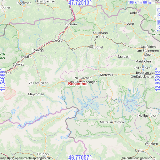
Rosenthal GPS coordinates[2]
47° 15' 0" North, 12° 15' 0" East
| Map corner | latitude | longitude |
|---|---|---|
| Upper-left | 47.72513°, | 11.54688° |
| Center: | 47.25°, | 12.25° |
| Lower-right: | 46.77057°, | 12.95313° |
| Map W x H: | 106.1×106.1 km | = 65.9×65.9mi |
| max Lat: | 48.98333° ⇑69.4% North |
| Rosenthal: | 47.25° |
| min Lat: | ⇓30.6% South 46.48841° |
| min Long | Rosenthal | max Long |
| 9.57802° | 12.25° | 17.1° |
| W 12.7%⇐ | ⇒87.3% E |
Elevation
Elevation of Rosenthal is 909 m = 2982 ft, and this is 403.5 m = 1324 ft above average elevation for this country.
| Max E: |
2140 m = 7021 ft | 8.6% |
| Rosenthal | 909 m 2982 ft | |
| Avg. | 505.5 m = 1658 ft | |
Min E: |
118 m = 387 ft | 91.4% |
See also: Austria elevation on elevation.city.
Geographical zone
Rosenthal is located in North temperate zone (between Tropic of Cancer and the Arctic Circle). Distance of this North polar circle is 2147.5 km =1334.4 mi to North.| Distance of | km | miles | from Rosenthal |
|---|---|---|---|
| North Pole | 4753.4 | 2953.6 | to North |
| Arctic Circle | 2147.5 | 1334.4 | to North |
| Tropic Cancer | 2647.8 | 1645.3 | to South |
| Equator | 5253.7 | 3264.5 | to South |


Nearby cities:
15 places around Rosenthal: (largest is in red/bold)
• Bramberg am Wildkogel
7 km =4.3 mi,  71°
71°
• Burk
18.9 km =11.7 mi,  77°
77°
• Felben
18 km =11.2 mi, 78°
• Gerlos
16.8 km =10.4 mi,  260°
260°
• Hollersbach im Pinzgau
13.4 km =8.3 mi, 77°
• Jochberg
19.2 km =11.9 mi,  41°
41°
• Kelchsau
17.2 km =10.7 mi,  329°
329°
• Krimml
6.7 km =4.2 mi,  237°
237°
• Mittersill
18 km =11.2 mi, 78°
• Neukirchen am Großvenediger
2 km =1.2 mi,  88°
88°
• Oberkrimml
7.3 km =4.5 mi, 239°
• Penningberg
21.3 km =13.2 mi, 333°
• Stuhlfelden
21.4 km =13.3 mi, 78°
• Wald im Pinzgau
1.3 km =0.8 mi,  270°
270°
• Westendorf
20.4 km =12.7 mi,  352°
352°
Sources, notices
• [Note1] Compared only with cities in Austria existing in our database
• [Src1] Map data: © OpenStreetMap contributors (CC-BY-SA)
• [Src2] Other city data from geonames.org with taken over terms of usage.
• [Src3] Geographical zone / Annual Mean Temperature by Robert A. Rohde @ Wikipedia
