Kelchsau geodata
Kelchsau (Tyrol) is a populated place; located in Austria in Europe/Vienna (GMT+2) time zone. With population of 662 people, there are 1951 cities with bigger population in this country. Compared to other cities in Austria, 60.9% of cities are located further ↑North; 88% of cities are located further →East and 86% of cities have lower elevation than Kelchsau. Note1
Administrative division(s):
- Level 1: Tyrol
- Level 2: Politischer Bezirk Kitzbühel
- Level 3: Hopfgarten im Brixental


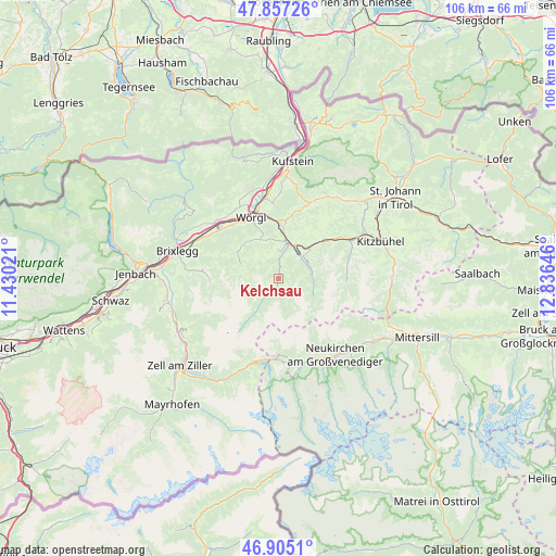
Kelchsau GPS coordinates[2]
47° 22' 59.988" North, 12° 7' 59.988" East
| Map corner | latitude | longitude |
|---|---|---|
| Upper-left | 47.85726°, | 11.43021° |
| Center: | 47.38333°, | 12.13333° |
| Lower-right: | 46.9051°, | 12.83646° |
| Map W x H: | 105.9×105.9 km | = 65.8×65.8mi |
| max Lat: | 48.98333° ⇑60.9% North |
| Kelchsau: | 47.38333° |
| min Lat: | ⇓39.1% South 46.48841° |
| min Long | Kelchsau | max Long |
| 9.57802° | 12.13333° | 17.1° |
| W 12%⇐ | ⇒88% E |
Elevation
Elevation of Kelchsau is 814 m = 2671 ft, and this is 308.5 m = 1012 ft above average elevation for this country.
| Max E: |
2140 m = 7021 ft | 14% |
| Kelchsau | 814 m 2671 ft | |
| Avg. | 505.5 m = 1658 ft | |
Min E: |
118 m = 387 ft | 86% |
See also: Austria elevation on elevation.city.
Geographical zone
Kelchsau is located in North temperate zone (between Tropic of Cancer and the Arctic Circle). Distance of this North polar circle is 2132.6 km =1325.1 mi to North.| Distance of | km | miles | from Kelchsau |
|---|---|---|---|
| North Pole | 4738.5 | 2944.4 | to North |
| Arctic Circle | 2132.6 | 1325.1 | to North |
| Tropic Cancer | 2662.6 | 1654.5 | to South |
| Equator | 5268.5 | 3273.7 | to South |


Nearby cities:
15 places around Kelchsau: (largest is in red/bold)
• Alpbach
14.4 km =8.9 mi,  276°
276°
• Auffach
7.8 km =4.8 mi, 283°
• Bad Häring
14.2 km =8.8 mi,  355°
355°
• Brixen im Thale
11.5 km =7.1 mi,  49°
49°
• Grafenweg
7.7 km =4.8 mi,  345°
345°
• Hopfgarten im Brixental
7.6 km =4.7 mi,  13°
13°
• Itter
9.3 km =5.8 mi,  0°
0°
• Liesfeld
14.5 km =9 mi,  315°
315°
• Niederau
8.3 km =5.2 mi,  333°
333°
• Oberau
9.2 km =5.7 mi, 316°
• Penningberg
4.3 km =2.7 mi, 352°
• Söll
14.1 km =8.8 mi,  18°
18°
• Westendorf
8.1 km =5 mi, 48°
• Wildschönau
7.6 km =4.7 mi,  289°
289°
• Wörgl
12.9 km =8 mi,  335°
335°
Sources, notices
• [Note1] Compared only with cities in Austria existing in our database
• [Src1] Map data: © OpenStreetMap contributors (CC-BY-SA)
• [Src2] Other city data from geonames.org with taken over terms of usage.
• [Src3] Geographical zone / Annual Mean Temperature by Robert A. Rohde @ Wikipedia
