Gniebing geodata
Gniebing (Styria) is a populated place; located in Austria in Europe/Vienna (GMT+2) time zone. With population of 1,095 people, there are 1166 cities with bigger population in this country. Compared to other cities in Austria, 85.8% of cities are located further ↑North; 76.2% of cities are located further ←West and 75.2% of cities have higher elevation than Gniebing. Note1
Administrative division(s):
- Level 1: Styria
- Level 2: Politischer Bezirk Südoststeiermark
- Level 3: Feldbach


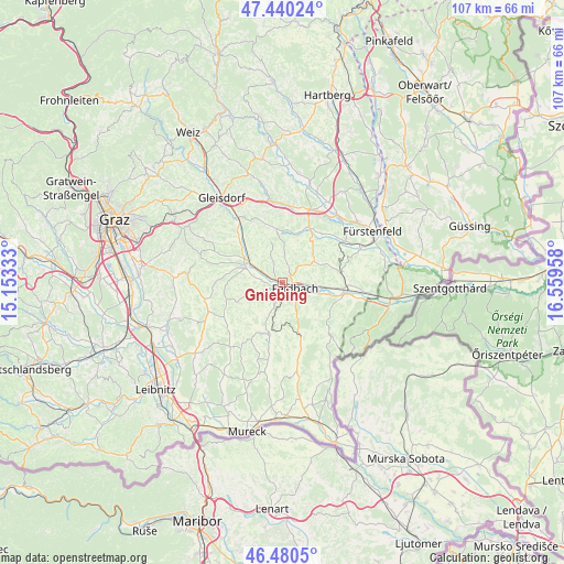
Gniebing GPS coordinates[2]
46° 57' 45.072" North, 15° 51' 23.22" East
| Map corner | latitude | longitude |
|---|---|---|
| Upper-left | 47.44024°, | 15.15333° |
| Center: | 46.96252°, | 15.85645° |
| Lower-right: | 46.4805°, | 16.55958° |
| Map W x H: | 106.7×106.7 km | = 66.3×66.3mi |
| max Lat: | 48.98333° ⇑85.8% North |
| Gniebing: | 46.96252° |
| min Lat: | ⇓14.2% South 46.48841° |
| min Long | Gniebing | max Long |
| 9.57802° | 15.85645° | 17.1° |
| W 76.2%⇐ | ⇒23.8% E |
Elevation
Elevation of Gniebing is 302 m = 991 ft, and this is 203.5 m = 668 ft below average elevation for this country.
| Max E: |
2140 m = 7021 ft | 75.2% |
| Avg. | 505.5 m = 1658 ft | |
| Gniebing | 302 m = 991 ft | |
Min E: |
118 m = 387 ft | 24.8% |
See also: Austria elevation on elevation.city.
Geographical zone
Gniebing is located in North temperate zone (between Tropic of Cancer and the Arctic Circle). Distance of this North polar circle is 2179.4 km =1354.2 mi to North.| Distance of | km | miles | from Gniebing |
|---|---|---|---|
| North Pole | 4785.3 | 2973.4 | to North |
| Arctic Circle | 2179.4 | 1354.2 | to North |
| Tropic Cancer | 2615.8 | 1625.4 | to South |
| Equator | 5221.7 | 3244.6 | to South |


Nearby cities:
15 places around Gniebing: (largest is in red/bold)
• Auersbach
6.1 km =3.8 mi,  7°
7°
• Edelsbach bei Feldbach
3.3 km =2.1 mi,  333°
333°
• Feldbach
2.6 km =1.6 mi,  113°
113°
• Fladnitz im Raabtal
6.3 km =3.9 mi,  300°
300°
• Leitersdorf im Raabtal
6.3 km =3.9 mi, 111°
• Lödersdorf
6.6 km =4.1 mi,  93°
93°
• Mitterfladnitz
6.8 km =4.2 mi,  322°
322°
• Mühldorf bei Feldbach
4.7 km =2.9 mi,  124°
124°
• Oberstorcha
4.3 km =2.7 mi,  276°
276°
• Oedt bei Feldbach
3 km =1.9 mi,  167°
167°
• Paldau
5.1 km =3.2 mi,  243°
243°
• Perlsdorf
6.3 km =3.9 mi,  210°
210°
• Raabau
4.2 km =2.6 mi, 89°
• Unterweissenbach
1.5 km =0.9 mi,  199°
199°
• Wörth bei Kirchberg an der Raab
6.8 km =4.2 mi,  273°
273°
Sources, notices
• [Note1] Compared only with cities in Austria existing in our database
• [Src1] Map data: © OpenStreetMap contributors (CC-BY-SA)
• [Src2] Other city data from geonames.org with taken over terms of usage.
• [Src3] Geographical zone / Annual Mean Temperature by Robert A. Rohde @ Wikipedia
