Thenneberg geodata
Thenneberg (Lower Austria) is a populated place; located in Austria in Europe/Vienna (GMT+2) time zone. With population of 558 people, there are 2283 cities with bigger population in this country. Compared to other cities in Austria, 67.6% of cities are located further ↓South; 79.3% of cities are located further ←West and 55.1% of cities have higher elevation than Thenneberg. Note1
Administrative division(s):
- Level 1: Lower Austria
- Level 2: Politischer Bezirk Baden
- Level 3: Altenmarkt an der Triesting


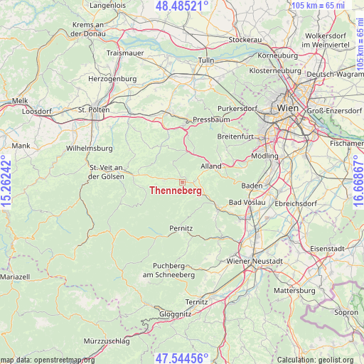
Thenneberg GPS coordinates[2]
48° 1' 1.308" North, 15° 57' 55.944" East
| Map corner | latitude | longitude |
|---|---|---|
| Upper-left | 48.48521°, | 15.26242° |
| Center: | 48.01703°, | 15.96554° |
| Lower-right: | 47.54456°, | 16.66867° |
| Map W x H: | 104.6×104.6 km | = 65×65mi |
| max Lat: | 48.98333° ⇑32.4% North |
| Thenneberg: | 48.01703° |
| min Lat: | ⇓67.6% South 46.48841° |
| min Long | Thenneberg | max Long |
| 9.57802° | 15.96554° | 17.1° |
| W 79.3%⇐ | ⇒20.7% E |
Elevation
Elevation of Thenneberg is 419 m = 1375 ft, and this is 86.5 m = 284 ft below average elevation for this country.
| Max E: |
2140 m = 7021 ft | 55.1% |
| Avg. | 505.5 m = 1658 ft | |
| Thenneberg | 419 m = 1375 ft | |
Min E: |
118 m = 387 ft | 44.9% |
See also: Austria elevation on elevation.city.
Geographical zone
Thenneberg is located in North temperate zone (between Tropic of Cancer and the Arctic Circle). Distance of this North polar circle is 2062.2 km =1281.4 mi to North.| Distance of | km | miles | from Thenneberg |
|---|---|---|---|
| North Pole | 4668.1 | 2900.6 | to North |
| Arctic Circle | 2062.2 | 1281.4 | to North |
| Tropic Cancer | 2733.1 | 1698.3 | to South |
| Equator | 5339 | 3317.5 | to South |


Nearby cities:
15 places around Thenneberg: (largest is in red/bold)
• Alland
9.6 km =6 mi,  61°
61°
• Altenmarkt an der Triesting
2.3 km =1.4 mi,  94°
94°
• Berndorf
13.3 km =8.3 mi,  126°
126°
• Furth an der Triesting
4.9 km =3 mi,  173°
173°
• Grub
12.9 km =8 mi, 57°
• Heiligenkreuz
12.6 km =7.8 mi,  70°
70°
• Innermanzing
13.6 km =8.5 mi,  343°
343°
• Kaumberg
5.1 km =3.2 mi,  279°
279°
• Klausen-Leopoldsdorf
8.7 km =5.4 mi,  25°
25°
• Muggendorf
12 km =7.5 mi,  190°
190°
• Neuhaus
6.5 km =4 mi,  112°
112°
• Pernitz
13.3 km =8.3 mi,  181°
181°
• Pottenstein
11.6 km =7.2 mi,  124°
124°
• Ramsau
12.2 km =7.6 mi,  262°
262°
• Weissenbach an der Triesting
6.7 km =4.2 mi, 125°
Sources, notices
• [Note1] Compared only with cities in Austria existing in our database
• [Src1] Map data: © OpenStreetMap contributors (CC-BY-SA)
• [Src2] Other city data from geonames.org with taken over terms of usage.
• [Src3] Geographical zone / Annual Mean Temperature by Robert A. Rohde @ Wikipedia
