Mattersburg geodata
Mattersburg (Burgenland) is a seat of a second-order administrative division; located in Austria in Europe/Vienna (GMT+2) time zone. With population of 6,577 people, there are 143 cities with bigger population in this country. Compared to other cities in Austria, 54.9% of cities are located further ↓South; 91.2% of cities are located further ←West and 81.7% of cities have higher elevation than Mattersburg. Note1
Administrative division(s):
- Level 1: Burgenland
- Level 2: Politischer Bezirk Mattersburg
- Level 3: Mattersburg


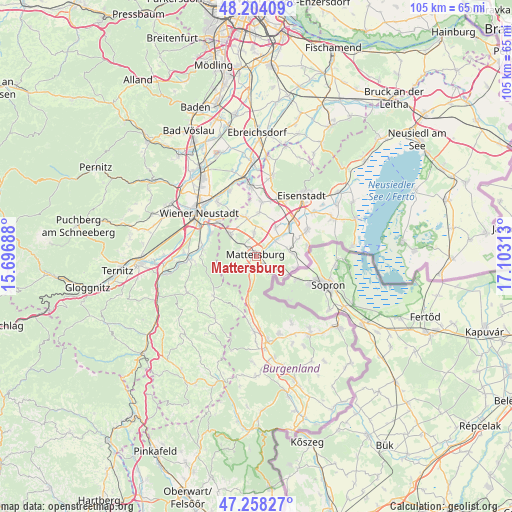
Mattersburg GPS coordinates[2]
47° 43' 59.988" North, 16° 24' 0" East
| Map corner | latitude | longitude |
|---|---|---|
| Upper-left | 48.20409°, | 15.69688° |
| Center: | 47.73333°, | 16.4° |
| Lower-right: | 47.25827°, | 17.10313° |
| Map W x H: | 105.2×105.2 km | = 65.4×65.4mi |
| max Lat: | 48.98333° ⇑45.1% North |
| Mattersburg: | 47.73333° |
| min Lat: | ⇓54.9% South 46.48841° |
| min Long | Mattersburg | max Long |
| 9.57802° | 16.4° | 17.1° |
| W 91.2%⇐ | ⇒8.8% E |
Elevation
Elevation of Mattersburg is 267 m = 876 ft, and this is 238.5 m = 782 ft below average elevation for this country.
| Max E: |
2140 m = 7021 ft | 81.7% |
| Avg. | 505.5 m = 1658 ft | |
| Mattersburg | 267 m = 876 ft | |
Min E: |
118 m = 387 ft | 18.3% |
See also: Austria elevation on elevation.city.
Geographical zone
Mattersburg is located in North temperate zone (between Tropic of Cancer and the Arctic Circle). Distance of this North polar circle is 2093.7 km =1301 mi to North.| Distance of | km | miles | from Mattersburg |
|---|---|---|---|
| North Pole | 4699.6 | 2920.2 | to North |
| Arctic Circle | 2093.7 | 1301 | to North |
| Tropic Cancer | 2701.5 | 1678.6 | to South |
| Equator | 5307.4 | 3297.9 | to South |


Nearby cities:
15 places around Mattersburg: (largest is in red/bold)
• Antau
7.5 km =4.7 mi,  53°
53°
• Bad Sauerbrunn
7 km =4.3 mi,  310°
310°
• Drassburg
6.7 km =4.2 mi,  77°
77°
• Forchtenstein
4.8 km =3 mi,  239°
239°
• Hirm
7.2 km =4.5 mi,  34°
34°
• Krensdorf
5.9 km =3.7 mi,  10°
10°
• Loipersbach im Burgenland
7.2 km =4.5 mi,  124°
124°
• Marz
2.2 km =1.4 mi,  146°
146°
• Pöttelsdorf
3.7 km =2.3 mi, 51°
• Rohrbach bei Mattersburg
3.9 km =2.4 mi,  144°
144°
• Sigless
4.7 km =2.9 mi,  355°
355°
• Stöttera
6 km =3.7 mi, 49°
• Walbersdorf
1.8 km =1.1 mi,  57°
57°
• Wiesen
4.7 km =2.9 mi,  276°
276°
• Zemendorf
5 km =3.1 mi, 49°
Sources, notices
• [Note1] Compared only with cities in Austria existing in our database
• [Src1] Map data: © OpenStreetMap contributors (CC-BY-SA)
• [Src2] Other city data from geonames.org with taken over terms of usage.
• [Src3] Geographical zone / Annual Mean Temperature by Robert A. Rohde @ Wikipedia
