Laussa geodata
Laussa (Upper Austria) is a seat of a third-order administrative division; located in Austria in Europe/Vienna (GMT+2) time zone. With population of 1,227 people, there are 1030 cities with bigger population in this country. Compared to other cities in Austria, 63.1% of cities are located further ↓South; 54.5% of cities are located further →East and 56% of cities have lower elevation than Laussa. Note1
Administrative division(s):
- Level 1: Upper Austria
- Level 2: Politischer Bezirk Steyr-Land
- Level 3: Laussa


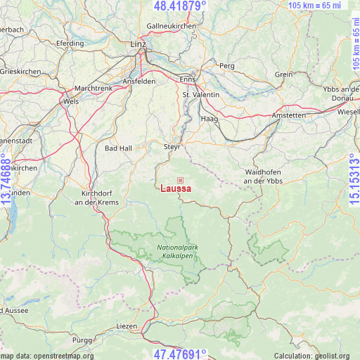
Laussa GPS coordinates[2]
47° 57' 0" North, 14° 27' 0" East
| Map corner | latitude | longitude |
|---|---|---|
| Upper-left | 48.41879°, | 13.74688° |
| Center: | 47.95°, | 14.45° |
| Lower-right: | 47.47691°, | 15.15313° |
| Map W x H: | 104.7×104.7 km | = 65.1×65.1mi |
| max Lat: | 48.98333° ⇑36.9% North |
| Laussa: | 47.95° |
| min Lat: | ⇓63.1% South 46.48841° |
| min Long | Laussa | max Long |
| 9.57802° | 14.45° | 17.1° |
| W 45.5%⇐ | ⇒54.5% E |
Elevation
Elevation of Laussa is 492 m = 1614 ft, and this is 13.5 m = 44 ft below average elevation for this country.
| Max E: |
2140 m = 7021 ft | 44% |
| Avg. | 505.5 m = 1658 ft | |
| Laussa | 492 m = 1614 ft | |
Min E: |
118 m = 387 ft | 56% |
See also: Austria elevation on elevation.city.
Geographical zone
Laussa is located in North temperate zone (between Tropic of Cancer and the Arctic Circle). Distance of this North polar circle is 2069.6 km =1286 mi to North.| Distance of | km | miles | from Laussa |
|---|---|---|---|
| North Pole | 4675.5 | 2905.2 | to North |
| Arctic Circle | 2069.6 | 1286 | to North |
| Tropic Cancer | 2725.6 | 1693.6 | to South |
| Equator | 5331.5 | 3312.8 | to South |


Nearby cities:
15 places around Laussa: (largest is in red/bold)
• Arzberg
6.7 km =4.2 mi,  158°
158°
• Aschach an der Steyr
11 km =6.8 mi,  309°
309°
• Behamberg
7.8 km =4.8 mi,  18°
18°
• Garsten
8.6 km =5.3 mi,  338°
338°
• Grossraming
10.5 km =6.5 mi,  134°
134°
• Kleinraming
6.1 km =3.8 mi, 24°
• Kürnberg
8.3 km =5.2 mi,  48°
48°
• Lahrndorf
7.2 km =4.5 mi, 313°
• Losenstein
3 km =1.9 mi,  199°
199°
• Penz
9.6 km =6 mi,  14°
14°
• Reichraming
7.4 km =4.6 mi,  180°
180°
• Sankt Ulrich bei Steyr
8 km =5 mi,  352°
352°
• Steyr
10.5 km =6.5 mi, 348°
• Ternberg
6.8 km =4.2 mi,  265°
265°
• Unterwald
7.5 km =4.7 mi, 9°
Sources, notices
• [Note1] Compared only with cities in Austria existing in our database
• [Src1] Map data: © OpenStreetMap contributors (CC-BY-SA)
• [Src2] Other city data from geonames.org with taken over terms of usage.
• [Src3] Geographical zone / Annual Mean Temperature by Robert A. Rohde @ Wikipedia
