Kürnberg geodata
Kürnberg (Lower Austria) is a populated place; located in Austria in Europe/Vienna (GMT+2) time zone. With population of 822 people, there are 1575 cities with bigger population in this country. Compared to other cities in Austria, 66.1% of cities are located further ↓South; 52.7% of cities are located further →East and 68.5% of cities have lower elevation than Kürnberg. Note1
Administrative division(s):
- Level 1: Lower Austria
- Level 2: Politischer Bezirk Amstetten
- Level 3: Sankt Peter in der Au


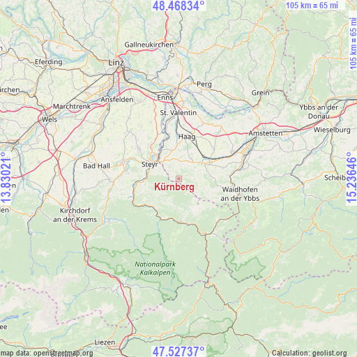
Kürnberg GPS coordinates[2]
48° 0' 0" North, 14° 31' 59.988" East
| Map corner | latitude | longitude |
|---|---|---|
| Upper-left | 48.46834°, | 13.83021° |
| Center: | 48°, | 14.53333° |
| Lower-right: | 47.52737°, | 15.23646° |
| Map W x H: | 104.6×104.6 km | = 65×65mi |
| max Lat: | 48.98333° ⇑33.9% North |
| Kürnberg: | 48° |
| min Lat: | ⇓66.1% South 46.48841° |
| min Long | Kürnberg | max Long |
| 9.57802° | 14.53333° | 17.1° |
| W 47.3%⇐ | ⇒52.7% E |
Elevation
Elevation of Kürnberg is 575 m = 1886 ft, and this is 69.5 m = 228 ft above average elevation for this country.
| Max E: |
2140 m = 7021 ft | 31.5% |
| Kürnberg | 575 m 1886 ft | |
| Avg. | 505.5 m = 1658 ft | |
Min E: |
118 m = 387 ft | 68.5% |
See also: Austria elevation on elevation.city.
Geographical zone
Kürnberg is located in North temperate zone (between Tropic of Cancer and the Arctic Circle). Distance of this North polar circle is 2064.1 km =1282.6 mi to North.| Distance of | km | miles | from Kürnberg |
|---|---|---|---|
| North Pole | 4670 | 2901.8 | to North |
| Arctic Circle | 2064.1 | 1282.6 | to North |
| Tropic Cancer | 2731.2 | 1697.1 | to South |
| Equator | 5337.1 | 3316.3 | to South |


Nearby cities:
15 places around Kürnberg: (largest is in red/bold)
• Behamberg
4.2 km =2.6 mi,  296°
296°
• Ertl
7.7 km =4.8 mi,  109°
109°
• Garsten
9.7 km =6 mi,  284°
284°
• Kleinraming
3.7 km =2.3 mi,  270°
270°
• Laussa
8.3 km =5.2 mi,  228°
228°
• Maria Neustift
8.9 km =5.5 mi,  146°
146°
• Penz
5.3 km =3.3 mi,  314°
314°
• Sankt Michael am Bruckbach
5.3 km =3.3 mi,  69°
69°
• Sankt Peter in der Au Markt
8.2 km =5.1 mi,  53°
53°
• Sankt Ulrich bei Steyr
7.6 km =4.7 mi,  288°
288°
• Seitenstetten Markt
9.4 km =5.8 mi, 66°
• Steyr
9.6 km =6 mi, 299°
• Unterwald
5.3 km =3.3 mi, 290°
• Wanzenöd
7 km =4.3 mi,  322°
322°
• Weistrach
6.7 km =4.2 mi,  33°
33°
Sources, notices
• [Note1] Compared only with cities in Austria existing in our database
• [Src1] Map data: © OpenStreetMap contributors (CC-BY-SA)
• [Src2] Other city data from geonames.org with taken over terms of usage.
• [Src3] Geographical zone / Annual Mean Temperature by Robert A. Rohde @ Wikipedia
