Loich geodata
Loich (Lower Austria) is a seat of a third-order administrative division; located in Austria in Europe/Vienna (GMT+2) time zone. With population of 216 people, there are 2837 cities with bigger population in this country. Compared to other cities in Austria, 65.9% of cities are located further ↓South; 62.8% of cities are located further ←West and 53% of cities have higher elevation than Loich. Note1
Administrative division(s):
- Level 1: Lower Austria
- Level 2: Politischer Bezirk Sankt Pölten
- Level 3: Loich


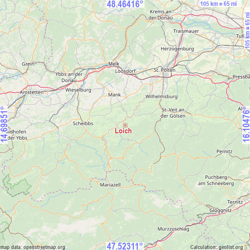
Loich GPS coordinates[2]
47° 59' 44.808" North, 15° 24' 5.868" East
| Map corner | latitude | longitude |
|---|---|---|
| Upper-left | 48.46416°, | 14.69851° |
| Center: | 47.99578°, | 15.40163° |
| Lower-right: | 47.52311°, | 16.10476° |
| Map W x H: | 104.6×104.6 km | = 65×65mi |
| max Lat: | 48.98333° ⇑34.1% North |
| Loich: | 47.99578° |
| min Lat: | ⇓65.9% South 46.48841° |
| min Long | Loich | max Long |
| 9.57802° | 15.40163° | 17.1° |
| W 62.8%⇐ | ⇒37.2% E |
Elevation
Elevation of Loich is 435 m = 1427 ft, and this is 70.5 m = 231 ft below average elevation for this country.
| Max E: |
2140 m = 7021 ft | 53% |
| Avg. | 505.5 m = 1658 ft | |
| Loich | 435 m = 1427 ft | |
Min E: |
118 m = 387 ft | 47% |
See also: Austria elevation on elevation.city.
Geographical zone
Loich is located in North temperate zone (between Tropic of Cancer and the Arctic Circle). Distance of this North polar circle is 2064.5 km =1282.8 mi to North.| Distance of | km | miles | from Loich |
|---|---|---|---|
| North Pole | 4670.4 | 2902.1 | to North |
| Arctic Circle | 2064.5 | 1282.8 | to North |
| Tropic Cancer | 2730.7 | 1696.8 | to South |
| Equator | 5336.6 | 3316 | to South |


Nearby cities:
15 places around Loich: (largest is in red/bold)
• Dorf Au
9.2 km =5.7 mi,  30°
30°
• Eschenau
13.6 km =8.5 mi,  64°
64°
• Frankenfels
5.8 km =3.6 mi,  255°
255°
• Hofstetten
13.9 km =8.6 mi,  35°
35°
• Kilb
11.7 km =7.3 mi,  2°
2°
• Kirchberg an der Pielach
4 km =2.5 mi, 30°
• Kirnberg an der Mank
10.4 km =6.5 mi,  325°
325°
• Mank
13.5 km =8.4 mi,  339°
339°
• Puchenstuben
11.3 km =7 mi,  228°
228°
• Rabenstein an der Pielach
9.2 km =5.7 mi, 32°
• Sankt Georgen an der Leys
13.6 km =8.5 mi,  287°
287°
• Schwarzenbach an der Pielach
7.1 km =4.4 mi,  191°
191°
• Soisgegend
4.1 km =2.5 mi,  95°
95°
• Stangental
13.4 km =8.3 mi,  83°
83°
• Türnitz
9.9 km =6.2 mi,  136°
136°
Sources, notices
• [Note1] Compared only with cities in Austria existing in our database
• [Src1] Map data: © OpenStreetMap contributors (CC-BY-SA)
• [Src2] Other city data from geonames.org with taken over terms of usage.
• [Src3] Geographical zone / Annual Mean Temperature by Robert A. Rohde @ Wikipedia
