Leibnitz geodata
Leibnitz (Styria) is a seat of a third-order administrative division; located in Austria in Europe/Vienna (GMT+2) time zone. With population of 8,533 people, there are 100 cities with bigger population in this country. Compared to other cities in Austria, 92.3% of cities are located further ↑North; 66.7% of cities are located further ←West and 80.4% of cities have higher elevation than Leibnitz. Note1


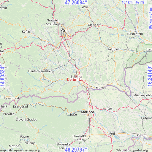
Leibnitz GPS coordinates[2]
46° 46' 53.796" North, 15° 32' 18.096" East
| Map corner | latitude | longitude |
|---|---|---|
| Upper-left | 47.26094°, | 14.83524° |
| Center: | 46.78161°, | 15.53836° |
| Lower-right: | 46.29797°, | 16.24149° |
| Map W x H: | 107.1×107.1 km | = 66.5×66.5mi |
| max Lat: | 48.98333° ⇑92.3% North |
| Leibnitz: | 46.78161° |
| min Lat: | ⇓7.7% South 46.48841° |
| min Long | Leibnitz | max Long |
| 9.57802° | 15.53836° | 17.1° |
| W 66.7%⇐ | ⇒33.3% E |
Elevation
Elevation of Leibnitz is 273 m = 896 ft, and this is 232.5 m = 763 ft below average elevation for this country.
| Max E: |
2140 m = 7021 ft | 80.4% |
| Avg. | 505.5 m = 1658 ft | |
| Leibnitz | 273 m = 896 ft | |
Min E: |
118 m = 387 ft | 19.6% |
See also: Austria elevation on elevation.city.
Geographical zone
Leibnitz is located in North temperate zone (between Tropic of Cancer and the Arctic Circle). Distance of this North polar circle is 2199.5 km =1366.7 mi to North.| Distance of | km | miles | from Leibnitz |
|---|---|---|---|
| North Pole | 4805.4 | 2985.9 | to North |
| Arctic Circle | 2199.5 | 1366.7 | to North |
| Tropic Cancer | 2595.7 | 1612.9 | to South |
| Equator | 5201.6 | 3232.1 | to South |


Nearby cities:
15 places around Leibnitz: (largest is in red/bold)
• Gabersdorf
3.5 km =2.2 mi,  97°
97°
• Gamlitz
6.9 km =4.3 mi,  170°
170°
• Gralla
3.8 km =2.4 mi,  19°
19°
• Heimschuh
4.2 km =2.6 mi,  235°
235°
• Kaindorf an der Sulm
1.2 km =0.7 mi,  1°
1°
• Kitzeck im Sausal
6.4 km =4 mi,  269°
269°
• Lang
6.7 km =4.2 mi,  337°
337°
• Leitring
2.7 km =1.7 mi,  127°
127°
• Neutillmitsch
3.9 km =2.4 mi,  354°
354°
• Obervogau
5.4 km =3.4 mi,  139°
139°
• Retznei
5.8 km =3.6 mi,  158°
158°
• Seggauberg
2.3 km =1.4 mi,  224°
224°
• Tillmitsch
3.8 km =2.4 mi,  334°
334°
• Tillmitsch Links der Laßnitz
3.3 km =2.1 mi, 340°
• Wagna
2.3 km =1.4 mi, 136°
Sources, notices
• [Note1] Compared only with cities in Austria existing in our database
• [Src1] Map data: © OpenStreetMap contributors (CC-BY-SA)
• [Src2] Other city data from geonames.org with taken over terms of usage.
• [Src3] Geographical zone / Annual Mean Temperature by Robert A. Rohde @ Wikipedia
