Seggauberg geodata
Seggauberg (Styria) is a seat of a third-order administrative division; located in Austria in Europe/Vienna (GMT+2) time zone. With population of 525 people, there are 2408 cities with bigger population in this country. Compared to other cities in Austria, 93% of cities are located further ↑North; 65.9% of cities are located further ←West and 70.8% of cities have higher elevation than Seggauberg. Note1


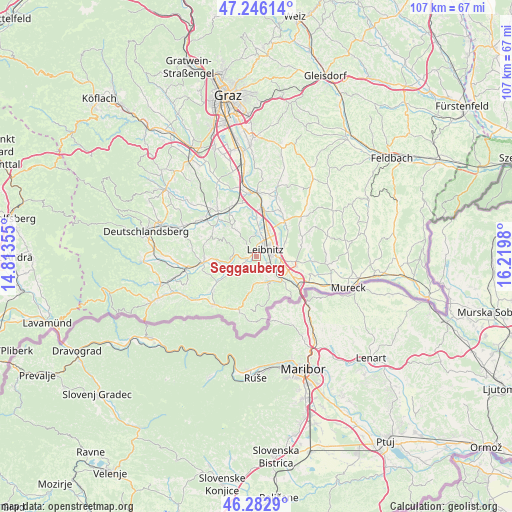
Seggauberg GPS coordinates[2]
46° 46' 0.012" North, 15° 31' 0.012" East
| Map corner | latitude | longitude |
|---|---|---|
| Upper-left | 47.24614°, | 14.81355° |
| Center: | 46.76667°, | 15.51667° |
| Lower-right: | 46.2829°, | 16.2198° |
| Map W x H: | 107.1×107.1 km | = 66.5×66.5mi |
| max Lat: | 48.98333° ⇑93% North |
| Seggauberg: | 46.76667° |
| min Lat: | ⇓7% South 46.48841° |
| min Long | Seggauberg | max Long |
| 9.57802° | 15.51667° | 17.1° |
| W 65.9%⇐ | ⇒34.1% E |
Elevation
Elevation of Seggauberg is 324 m = 1063 ft, and this is 181.5 m = 595 ft below average elevation for this country.
| Max E: |
2140 m = 7021 ft | 70.8% |
| Avg. | 505.5 m = 1658 ft | |
| Seggauberg | 324 m = 1063 ft | |
Min E: |
118 m = 387 ft | 29.2% |
See also: Austria elevation on elevation.city.
Geographical zone
Seggauberg is located in North temperate zone (between Tropic of Cancer and the Arctic Circle). Distance of this North polar circle is 2201.2 km =1367.8 mi to North.| Distance of | km | miles | from Seggauberg |
|---|---|---|---|
| North Pole | 4807.1 | 2987 | to North |
| Arctic Circle | 2201.2 | 1367.8 | to North |
| Tropic Cancer | 2594 | 1611.8 | to South |
| Equator | 5200 | 3231.1 | to South |


Nearby cities:
15 places around Seggauberg: (largest is in red/bold)
• Gabersdorf
5.3 km =3.3 mi,  77°
77°
• Gamlitz
5.9 km =3.7 mi,  151°
151°
• Gralla
6 km =3.7 mi,  29°
29°
• Großklein
6.5 km =4 mi,  238°
238°
• Heimschuh
1.9 km =1.2 mi,  247°
247°
• Kaindorf an der Sulm
3.3 km =2.1 mi, 30°
• Kitzeck im Sausal
5 km =3.1 mi,  288°
288°
• Leibnitz
2.3 km =1.4 mi,  44°
44°
• Leitring
3.8 km =2.4 mi,  90°
90°
• Neutillmitsch
5.7 km =3.5 mi,  12°
12°
• Obervogau
5.7 km =3.5 mi,  114°
114°
• Retznei
5.3 km =3.3 mi,  134°
134°
• Tillmitsch
5 km =3.1 mi,  0°
0°
• Tillmitsch Links der Laßnitz
4.8 km =3 mi, 6°
• Wagna
3.2 km =2 mi, 89°
Sources, notices
• [Note1] Compared only with cities in Austria existing in our database
• [Src1] Map data: © OpenStreetMap contributors (CC-BY-SA)
• [Src2] Other city data from geonames.org with taken over terms of usage.
• [Src3] Geographical zone / Annual Mean Temperature by Robert A. Rohde @ Wikipedia
