Obervogau geodata
Obervogau (Styria) is a seat of a third-order administrative division; located in Austria in Europe/Vienna (GMT+2) time zone. With population of 871 people, there are 1486 cities with bigger population in this country. Compared to other cities in Austria, 93.8% of cities are located further ↑North; 68.2% of cities are located further ←West and 82.8% of cities have higher elevation than Obervogau. Note1
Administrative division(s):
- Level 1: Styria
- Level 2: Politischer Bezirk Leibnitz
- Level 3: Straß-Spielfeld


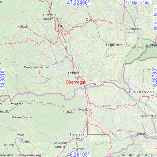
Obervogau GPS coordinates[2]
46° 44' 42" North, 15° 35' 4.992" East
| Map corner | latitude | longitude |
|---|---|---|
| Upper-left | 47.22466°, | 14.8816° |
| Center: | 46.745°, | 15.58472° |
| Lower-right: | 46.26103°, | 16.28785° |
| Map W x H: | 107.1×107.1 km | = 66.5×66.5mi |
| max Lat: | 48.98333° ⇑93.8% North |
| Obervogau: | 46.745° |
| min Lat: | ⇓6.2% South 46.48841° |
| min Long | Obervogau | max Long |
| 9.57802° | 15.58472° | 17.1° |
| W 68.2%⇐ | ⇒31.8% E |
Elevation
Elevation of Obervogau is 260 m = 853 ft, and this is 245.5 m = 805 ft below average elevation for this country.
| Max E: |
2140 m = 7021 ft | 82.8% |
| Avg. | 505.5 m = 1658 ft | |
| Obervogau | 260 m = 853 ft | |
Min E: |
118 m = 387 ft | 17.2% |
See also: Austria elevation on elevation.city.
Geographical zone
Obervogau is located in North temperate zone (between Tropic of Cancer and the Arctic Circle). Distance of this North polar circle is 2203.6 km =1369.3 mi to North.| Distance of | km | miles | from Obervogau |
|---|---|---|---|
| North Pole | 4809.5 | 2988.5 | to North |
| Arctic Circle | 2203.6 | 1369.3 | to North |
| Tropic Cancer | 2591.6 | 1610.3 | to South |
| Equator | 5197.6 | 3229.6 | to South |


Nearby cities:
15 places around Obervogau: (largest is in red/bold)
• Ehrenhausen
2.3 km =1.4 mi,  176°
176°
• Gabersdorf
3.6 km =2.2 mi,  359°
359°
• Gamlitz
3.6 km =2.2 mi,  221°
221°
• Heimschuh
7.2 km =4.5 mi,  283°
283°
• Kaindorf an der Sulm
6.3 km =3.9 mi,  326°
326°
• Leibnitz
5.4 km =3.4 mi,  319°
319°
• Leitring
2.8 km =1.7 mi, 330°
• Ratsch an der Weinstraße
6.3 km =3.9 mi,  189°
189°
• Retznei
1.9 km =1.2 mi,  226°
226°
• Sankt Veit am Vogau
4.4 km =2.7 mi,  96°
96°
• Seggauberg
5.7 km =3.5 mi,  294°
294°
• Spielfeld
5.9 km =3.7 mi,  137°
137°
• Straß in Steiermark
3.6 km =2.2 mi,  123°
123°
• Vogau
2.3 km =1.4 mi,  129°
129°
• Wagna
3.1 km =1.9 mi, 321°
Sources, notices
• [Note1] Compared only with cities in Austria existing in our database
• [Src1] Map data: © OpenStreetMap contributors (CC-BY-SA)
• [Src2] Other city data from geonames.org with taken over terms of usage.
• [Src3] Geographical zone / Annual Mean Temperature by Robert A. Rohde @ Wikipedia
