Södingberg geodata
Södingberg (Styria) is a seat of a third-order administrative division; located in Austria in Europe/Vienna (GMT+2) time zone. With population of 774 people, there are 1666 cities with bigger population in this country. Compared to other cities in Austria, 78.6% of cities are located further ↑North; 57.2% of cities are located further ←West and 51% of cities have lower elevation than Södingberg. Note1
Administrative division(s):
- Level 1: Styria
- Level 2: Politischer Bezirk Voitsberg
- Level 3: Geistthal-Södingberg


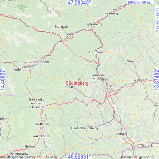
Södingberg GPS coordinates[2]
47° 6' 25.308" North, 15° 10' 18.084" East
| Map corner | latitude | longitude |
|---|---|---|
| Upper-left | 47.58345°, | 14.46857° |
| Center: | 47.10703°, | 15.17169° |
| Lower-right: | 46.62631°, | 15.87482° |
| Map W x H: | 106.4×106.4 km | = 66.1×66.1mi |
| max Lat: | 48.98333° ⇑78.6% North |
| Södingberg: | 47.10703° |
| min Lat: | ⇓21.4% South 46.48841° |
| min Long | Södingberg | max Long |
| 9.57802° | 15.17169° | 17.1° |
| W 57.2%⇐ | ⇒42.8% E |
Elevation
Elevation of Södingberg is 457 m = 1499 ft, and this is 48.5 m = 159 ft below average elevation for this country.
| Max E: |
2140 m = 7021 ft | 49% |
| Avg. | 505.5 m = 1658 ft | |
| Södingberg | 457 m = 1499 ft | |
Min E: |
118 m = 387 ft | 51% |
See also: Austria elevation on elevation.city.
Geographical zone
Södingberg is located in North temperate zone (between Tropic of Cancer and the Arctic Circle). Distance of this North polar circle is 2163.4 km =1344.3 mi to North.| Distance of | km | miles | from Södingberg |
|---|---|---|---|
| North Pole | 4769.3 | 2963.5 | to North |
| Arctic Circle | 2163.4 | 1344.3 | to North |
| Tropic Cancer | 2631.9 | 1635.4 | to South |
| Equator | 5237.8 | 3254.6 | to South |


Nearby cities:
15 places around Södingberg: (largest is in red/bold)
• Bärnbach
5.2 km =3.2 mi,  219°
219°
• Eisbach
7.3 km =4.5 mi,  81°
81°
• Geistthal
6.6 km =4.1 mi,  356°
356°
• Gradenberg
8.3 km =5.2 mi,  247°
247°
• Hochtregist
3 km =1.9 mi, 254°
• Jaritzberg
6.5 km =4 mi,  113°
113°
• Kainach bei Voitsberg
6.6 km =4.1 mi,  299°
299°
• Kohlschwarz
4.3 km =2.7 mi,  284°
284°
• Köflach
8.1 km =5 mi,  236°
236°
• Piberegg
4.4 km =2.7 mi, 251°
• Rosental an der Kainach
7.2 km =4.5 mi,  211°
211°
• Sankt Oswald bei Plankenwarth
8.3 km =5.2 mi, 105°
• Stallhofen
7.2 km =4.5 mi,  151°
151°
• Stiwoll
3.5 km =2.2 mi,  102°
102°
• Voitsberg
7.1 km =4.4 mi,  191°
191°
Sources, notices
• [Note1] Compared only with cities in Austria existing in our database
• [Src1] Map data: © OpenStreetMap contributors (CC-BY-SA)
• [Src2] Other city data from geonames.org with taken over terms of usage.
• [Src3] Geographical zone / Annual Mean Temperature by Robert A. Rohde @ Wikipedia
