Großharras geodata
Großharras (Lower Austria) is a seat of a third-order administrative division; located in Austria in Europe/Vienna (GMT+2) time zone. With population of 482 people, there are 2525 cities with bigger population in this country. Compared to other cities in Austria, 97.6% of cities are located further ↓South; 87.2% of cities are located further ←West and 92.5% of cities have higher elevation than Großharras. Note1
Administrative division(s):
- Level 1: Lower Austria
- Level 2: Politischer Bezirk Mistelbach
- Level 3: Großharras


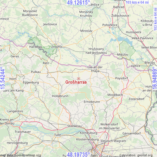
Großharras GPS coordinates[2]
48° 39' 50.004" North, 16° 14' 44.016" East
| Map corner | latitude | longitude |
|---|---|---|
| Upper-left | 49.12615°, | 15.54244° |
| Center: | 48.66389°, | 16.24556° |
| Lower-right: | 48.19735°, | 16.94869° |
| Map W x H: | 103.3×103.3 km | = 64.2×64.2mi |
| max Lat: | 48.98333° ⇑2.4% North |
| Großharras: | 48.66389° |
| min Lat: | ⇓97.6% South 46.48841° |
| min Long | Großharras | max Long |
| 9.57802° | 16.24556° | 17.1° |
| W 87.2%⇐ | ⇒12.8% E |
Elevation
Elevation of Großharras is 195 m = 640 ft, and this is 310.5 m = 1019 ft below average elevation for this country.
| Max E: |
2140 m = 7021 ft | 92.5% |
| Avg. | 505.5 m = 1658 ft | |
| Großharras | 195 m = 640 ft | |
Min E: |
118 m = 387 ft | 7.5% |
See also: Austria elevation on elevation.city.
Geographical zone
Großharras is located in North temperate zone (between Tropic of Cancer and the Arctic Circle). Distance of this North polar circle is 1990.3 km =1236.7 mi to North.| Distance of | km | miles | from Großharras |
|---|---|---|---|
| North Pole | 4596.1 | 2855.9 | to North |
| Arctic Circle | 1990.3 | 1236.7 | to North |
| Tropic Cancer | 2805 | 1742.9 | to South |
| Equator | 5410.9 | 3362.2 | to South |


Nearby cities:
15 places around Großharras: (largest is in red/bold)
• Alberndorf
11.4 km =7.1 mi,  290°
290°
• Fallbach
12.7 km =7.9 mi,  97°
97°
• Gaubitsch
10.2 km =6.3 mi, 98°
• Gnadendorf
12.5 km =7.8 mi,  114°
114°
• Großkadolz
6.9 km =4.3 mi,  321°
321°
• Hadres
9.9 km =6.2 mi,  301°
301°
• Hanfthal
9.8 km =6.1 mi,  65°
65°
• Haugsdorf
13.3 km =8.3 mi, 291°
• Laa an der Thaya
11.7 km =7.3 mi,  59°
59°
• Mailberg
4.8 km =3 mi,  283°
283°
• Obritz
8.1 km =5 mi, 299°
• Stronsdorf
4.2 km =2.6 mi, 109°
• Unterstinkenbrunn
7.4 km =4.6 mi,  86°
86°
• Wullersdorf
11.4 km =7.1 mi,  249°
249°
• Wulzeshofen
7.1 km =4.4 mi,  34°
34°
Sources, notices
• [Note1] Compared only with cities in Austria existing in our database
• [Src1] Map data: © OpenStreetMap contributors (CC-BY-SA)
• [Src2] Other city data from geonames.org with taken over terms of usage.
• [Src3] Geographical zone / Annual Mean Temperature by Robert A. Rohde @ Wikipedia
